El Salvador Volcanoes
-
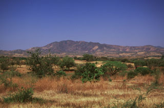
Apastepeque Field
-
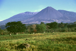
Izalco
-
Santa Ana
-

Apastepeque Field
-
Santa Ana
-

Apaneca Range
-
Apaneca Range
-
San Salvador
-
Apastepeque Field
-
Santa Ana
-
Izalco
-
Chinameca
-
Apaneca Range
-
San Vicente
-
Santa Ana
-
San Miguel
-
San Salvador
-
Apaneca Range
-
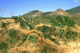
El Tigre
-

San Miguel
El Salvador has 20 Holocene volcanoes. Note that as a scientific organization we provide these listings for informational purposes only, with no international legal or policy implications. Volcanoes will be included on this list if they are within the boundaries of a country, on a shared boundary or area, in a remote territory, or within a maritime Exclusive Economic Zone. Bolded volcanoes have erupted within the past 20 years. Suggestions and data updates are always welcome ().
| Volcano Name | Location | Last Eruption | Primary Volcano Type |
|---|---|---|---|
| Apaneca Range | Western El Salvador | Unknown - Evidence Credible | Stratovolcano(es) |
| Apastepeque Field | Eastern El Salvador | Unknown - Evidence Credible | Volcanic field |
| Laguna Aramuaca | Eastern El Salvador | Unknown - Evidence Credible | Maar |
| Chinameca | Eastern El Salvador | Unknown - Evidence Credible | Stratovolcano |
| Chingo | Southeastern Guatemala | Unknown - Evidence Credible | Stratovolcano |
| Cerro Cinotepeque | Central El Salvador | Unknown - Evidence Credible | Volcanic field |
| Coatepeque Caldera | Western El Salvador | Unknown - Evidence Credible | Caldera |
| Guazapa | Central El Salvador | Unknown - Evidence Uncertain | Stratovolcano |
| Ilopango | Central El Salvador | 1880 CE | Caldera |
| Izalco | Western El Salvador | 1966 CE | Stratovolcano |
| San Diego | Western El Salvador | Unknown - Evidence Credible | Volcanic field |
| San Miguel | Eastern El Salvador | 2023 CE | Stratovolcano |
| San Salvador | Central El Salvador | 1917 CE | Stratovolcano |
| San Vicente | Central El Salvador | Unknown - Evidence Credible | Stratovolcano |
| Santa Ana | Western El Salvador | 2005 CE | Stratovolcano |
| Cerro Singuil | Western El Salvador | Unknown - Evidence Credible | Volcanic field |
| Taburete | Eastern El Salvador | Unknown - Evidence Uncertain | Stratovolcano |
| Tecapa | Eastern El Salvador | Unknown - Evidence Credible | Stratovolcano |
| El Tigre | Eastern El Salvador | Unknown - Evidence Credible | Stratovolcano |
| Usulutan | Eastern El Salvador | Unknown - Evidence Credible | Stratovolcano |
Chronological listing of known Holocene eruptions (confirmed or uncertain) from volcanoes in El Salvador. Bolded eruptions indicate continuing activity.
| Volcano Name | Start Date | Stop Date | Certainty | VEI | Evidence |
|---|---|---|---|---|---|
| San Miguel | 2022 Nov 15 | 2023 May 27 | Confirmed | 2 | Observations: Reported |
| San Miguel | 2020 Feb 22 | 2020 Feb 22 | Confirmed | 1 | Observations: Reported |
| San Miguel | 2018 Jan 14 | 2018 May 30 | Confirmed | 1 | Observations: Reported |
| San Miguel | 2017 Jan 7 | 2017 Jan 7 | Confirmed | 1 | Observations: Reported |
| San Miguel | 2016 Jun 18 | 2016 Jun 18 | Confirmed | 1 | Observations: Reported |
| San Miguel | 2016 Jan 12 | 2016 Jan 18 | Confirmed | 1 | Observations: Reported |
| San Miguel | 2015 Aug 13 | 2015 Aug 13 | Confirmed | 1 | Observations: Reported |
| San Miguel | 2015 Jan 26 | 2015 Apr 11 | Confirmed | 1 | Observations: Reported |
| San Miguel | 2013 Dec 29 | 2014 Jul 28 | Confirmed | 3 | Observations: Reported |
| Santa Ana | 2005 Jun 16 | 2005 Oct 1 (?) | Confirmed | 3 | Observations: Reported |
| San Miguel | 2002 Jan 16 | 2002 Jan 16 | Confirmed | 1 | Observations: Reported |
| San Miguel | 1997 Dec 31 | Unknown | Confirmed | 1 | Observations: Reported |
| San Miguel | 1995 Jan 12 | 1995 Apr 19 | Confirmed | 1 | Observations: Reported |
| San Miguel | 1985 Nov 16 ± 15 days | 1986 Feb 16 (in or after) ± 15 days | Confirmed | 1 | Observations: Reported |
| San Miguel | 1976 Dec 2 | 1977 Mar 1 | Confirmed | 1 | Observations: Reported |
| San Miguel | 1970 Mar 30 | 1970 Apr 5 | Confirmed | 1 | Observations: Reported |
| San Miguel | 1967 Jan 5 | Unknown | Confirmed | 2 | Observations: Reported |
| Izalco | 1966 Oct 28 | 1966 Nov 16 ± 15 days | Confirmed | 0 | Observations: Reported |
| San Miguel | 1966 Jul 16 ± 15 days | Unknown | Confirmed | 2 | Observations: Reported |
| San Miguel | 1966 Feb 22 | Unknown | Confirmed | 2 | Observations: Reported |
| San Miguel | 1965 Jun 14 | Unknown | Confirmed | 2 | Observations: Reported |
| San Miguel | 1964 Oct 23 | 1964 Nov 16 ± 15 days | Confirmed | 2 | Observations: Reported |
| San Miguel | 1954 Oct 21 | 1954 Oct 21 | Confirmed | 2 | Observations: Reported |
| Santa Ana | 1954 Apr ± 600 days | Unknown | Confirmed | Isotopic: 14C (calibrated) | |
| Izalco | 1948 Nov 4 | 1957 Dec 1 ± 30 days | Confirmed | 3 | Observations: Reported |
| San Miguel | 1939 May | 1939 Jul | Confirmed | 2 | Observations: Reported |
| Izalco | 1939 Feb | 1948 Feb | Confirmed | 2 | Observations: Reported |
| Izalco | 1937 (?) | 1938 (?) | Confirmed | 2 | Observations: Reported |
| San Miguel | [1936 (?)] | [Unknown] | Uncertain | ||
| Izalco | 1933 Nov 30 | 1934 Jan 12 (in or after) | Confirmed | 2 | Observations: Reported |
| Izalco | 1931 Mar 31 ± 90 days | Unknown | Confirmed | 2 | Observations: Reported |
| San Miguel | 1931 Mar | 1931 Jun | Confirmed | 2 | Observations: Reported |
| Izalco | 1930 Apr | Unknown | Confirmed | 0 | Observations: Reported |
| San Miguel | 1930 Jan 26 ± 5 days | Unknown | Confirmed | 2 | Observations: Reported |
| San Miguel | 1929 Aug | Unknown | Confirmed | 2 | Observations: Reported |
| Izalco | 1927 | 1928 (?) | Confirmed | 2 | Observations: Reported |
| Izalco | 1925 Dec 26 | 1927 Jan | Confirmed | 3 | Observations: Reported |
| Izalco | 1924 Mar | Unknown | Confirmed | 2 | Observations: Reported |
| Santa Ana | [1920 Nov] | [Unknown] | Uncertain | ||
| Izalco | 1920 Oct 29 | 1921 Apr 10 | Confirmed | 2 | Observations: Reported |
| San Miguel | 1920 Aug 14 | 1925 | Confirmed | 2 | Observations: Reported |
| San Miguel | 1919 Dec 10 | 1920 Jan | Confirmed | 2 | Observations: Reported |
| San Salvador | 1917 Jun 7 | 1917 Nov | Confirmed | 3 | Observations: Reported |
| Izalco | 1912 Jan 16 | 1916 Jan 26 | Confirmed | 2 | Observations: Reported |
| Santa Ana | 1904 Jan 12 | 1904 Jan 26 (?) | Confirmed | 2 | Observations: Reported |
| Izalco | 1903 Nov | 1905 Mar | Confirmed | 2 | Observations: Reported |
| Izalco | 1902 May 10 | 1902 Dec 30 | Confirmed | 2 | Observations: Reported |
| Izalco | 1899 Dec 31 | 1900 Mar | Confirmed | 2 | Observations: Reported |
| Izalco | 1891 | 1898 Jul | Confirmed | 2 | Observations: Reported |
| Izalco | 1890 Mar 26 ± 5 days | 1890 Apr 20 | Confirmed | 0 | Observations: Reported |
| San Miguel | 1890 | 1891 | Confirmed | 2 | Observations: Reported |
| Izalco | 1887 | 1889 | Confirmed | 2 | Observations: Reported |
| Izalco | 1885 | Unknown | Confirmed | 2 | Observations: Reported |
| Izalco | 1884 Mar 9 | 1884 Mar 10 | Confirmed | 2 | Observations: Reported |
| Santa Ana | 1884 Mar 9 | 1884 Mar 10 | Confirmed | 2 | Observations: Reported |
| San Miguel | 1884 Jan 25 | 1884 Jan 28 ± 1 days | Confirmed | 2 | Observations: Reported |
| Izalco | 1883 Sep 5 ± 4 days | 1883 Nov 13 | Confirmed | 2 | Observations: Reported |
| San Miguel | 1882 Dec 5 ± 4 days | Unknown | Confirmed | 2 | Observations: Reported |
| Izalco | 1882 Jul 12 | Unknown | Confirmed | 2 | Observations: Reported |
| Santa Ana | [1882] | [Unknown] | Uncertain | ||
| Izalco | 1881 Jan 1 | Unknown | Confirmed | 0 | Observations: Reported |
| Santa Ana | 1880 Mar | Unknown | Confirmed | 3 | Observations: Reported |
| Ilopango | 1879 Dec 31 | 1880 Mar 26 ± 5 days | Confirmed | 3 | Observations: Reported |
| Izalco | 1879 Dec 25 | 1880 Mar | Confirmed | 2 | Observations: Reported |
| Santa Ana | 1879 Feb 1 ± 30 days | Unknown | Confirmed | 2 | Observations: Reported |
| Tecapa | [1878 Oct 2] | [Unknown] | Uncertain | ||
| Izalco | 1878 | Unknown | Confirmed | Observations: Reported | |
| Santa Ana | [1878] | [Unknown] | Uncertain | ||
| Santa Ana | 1874 | Unknown | Confirmed | 3 | Observations: Reported |
| Izalco | [1874] | [1875] | Uncertain | ||
| Izalco | 1872 Dec | 1873 Mar 19 (in or after) | Confirmed | 2 | Observations: Reported |
| Izalco | [1870 May 19] | [Unknown] | Uncertain | ||
| Izalco | 1869 Mar 1 (?) | 1869 Jun 18 (in or after) | Confirmed | 2 | Observations: Reported |
| Izalco | 1868 Feb 16 | 1868 Feb 17 | Confirmed | 2 | Observations: Reported |
| San Miguel | 1867 Dec 14 | 1868 Feb 16 (in or after) | Confirmed | 2 | Observations: Reported |
| Izalco | 1867 Apr | 1867 Aug | Confirmed | 2 | Observations: Reported |
| Izalco | 1866 Apr 27 | 1866 Aug 15 ± 5 days | Confirmed | 2 | Observations: Reported |
| Izalco | 1864 May 15 ± 2 days | 1865 Jun 15 ± 5 days | Confirmed | 2 | Observations: Reported |
| Izalco | 1863 | Unknown | Confirmed | 0 | Observations: Reported |
| San Miguel | 1862 Jan | Unknown | Confirmed | 2 | Observations: Reported |
| Izalco | 1859 Dec 8 | 1860 Jan 22 | Confirmed | 0 | Observations: Reported |
| Izalco | 1858 Feb 6 | 1859 Jul | Confirmed | 2 | Observations: Reported |
| San Miguel | 1857 Nov | Unknown | Confirmed | 2 | Observations: Reported |
| Izalco | 1857 Feb 15 | 1857 Feb 19 (in or after) | Confirmed | 2 | Observations: Reported |
| Izalco | 1856 May 24 | 1856 Sep 1 ± 1 days | Confirmed | 2 | Observations: Reported |
| San Miguel | 1855 Dec | Unknown | Confirmed | 2 | Observations: Reported |
| Izalco | 1854 May 13 | 1854 Jun 8 | Confirmed | 2 | Observations: Reported |
| San Miguel | [1854] | [Unknown] | Uncertain | ||
| Izalco | 1850 | Unknown | Confirmed | 2 | Observations: Reported |
| San Miguel | 1844 Jul 25 | 1848 | Confirmed | 2 | Observations: Reported |
| Izalco | 1844 Jun | 1844 Oct | Confirmed | 2 | Observations: Reported |
| Izalco | 1842 | Unknown | Confirmed | 2 | Observations: Reported |
| Izalco | 1838 | 1840 | Confirmed | 2 | Observations: Reported |
| Izalco | 1836 | Unknown | Confirmed | 2 | Observations: Reported |
| Izalco | 1825 | Unknown | Confirmed | 2 | Observations: Reported |
| San Miguel | 1819 Jul 18 | Unknown | Confirmed | 2 | Observations: Reported |
| Izalco | 1817 | Unknown | Confirmed | 2 | Observations: Reported |
| San Miguel | [1811] | [Unknown] | Uncertain | ||
| San Salvador | [1806] | [Unknown] | Uncertain | ||
| Izalco | 1805 | 1807 | Confirmed | 2 | Observations: Reported |
| Izalco | 1802 | 1803 | Confirmed | 2 | Observations: Reported |
| Izalco | 1798 Apr | Unknown | Confirmed | 2 | Observations: Reported |
| San Miguel | [1798 (?)] | [Unknown] | Uncertain | ||
| Izalco | 1793 Mar 29 | 1793 Sep | Confirmed | 2 | Observations: Reported |
| San Miguel | 1787 Sep 21 | 1787 Sep 23 | Confirmed | 2 | Observations: Reported |
| Izalco | 1783 Jul (?) | Unknown | Confirmed | 0 | Observations: Reported |
| Izalco | 1772 (?) | Unknown | Confirmed | 2 | Observations: Reported |
| Izalco | 1770 Feb 23 | Unknown | Confirmed | 2 | Observations: Reported |
| San Miguel | 1769 | Unknown | Confirmed | 2 | Observations: Reported |
| San Miguel | 1762 | Unknown | Confirmed | 2 | Observations: Reported |
| Santa Ana | 1734 Jun (in or before) | Unknown | Confirmed | 2 | Observations: Reported |
| Santa Ana | 1722 Mar 12 | Unknown | Confirmed | 2 | Observations: Reported |
| San Miguel | 1699 | Unknown | Confirmed | 2 | Observations: Reported |
| San Salvador | 1658 Nov 3 | 1671 Aug (in or after) | Confirmed | 3 | Observations: Reported |
| Santa Ana | [1621] | [Unknown] | Uncertain | ||
| Santa Ana | 1576 | Unknown | Confirmed | 3 | Observations: Reported |
| San Salvador | 1575 | Unknown | Confirmed | 3 | Observations: Reported |
| Santa Ana | 1570 (?) | Unknown | Confirmed | Observations: Reported | |
| Santa Ana | 1524 Apr 30 ± 30 days | Unknown | Confirmed | 3 | Observations: Reported |
| Santa Ana | 1521 Dec 31 ± 365 days | Unknown | Confirmed | 3 | Observations: Reported |
| Santa Ana | [1520] | [Unknown] | Uncertain | ||
| San Miguel | 1510 ± 5 years | Unknown | Confirmed | Observations: Reported | |
| San Salvador | 1200 (?) | Unknown | Confirmed | 4 | Correlation: Anthropology |
| San Salvador | 0640 Aug ± 30 years | Unknown | Confirmed | 3 | Isotopic: 14C (calibrated) |
| Ilopango | 0450 ± 30 years | Unknown | Confirmed | 6 | Isotopic: 14C (calibrated) |
El Salvador has 12 Pleistocene volcanoes. Note that as a scientific organization we provide these listings for informational purposes only, with no international legal or policy implications. Volcanoes will be included on this list if they are within the boundaries of a country, on a shared boundary or area, in a remote territory, or within a maritime Exclusive Economic Zone. Suggestions and data updates are always welcome ().
| Volcano Name | Location | Primary Volcano Type |
|---|---|---|
| Cerro Buena Vista | El Salvador and Honduras | Stratovolcano |
| Cerro Cacahuatique | El Salvador and Honduras | Stratovolcano |
| Conchagua | El Salvador and Honduras | Stratovolcano |
| Conchaguita | El Salvador and Honduras | Stratovolcano |
| Los Limones Volcanic Field | El Salvador and Honduras | Pyroclastic cone(s) |
| Cerro Lolotique | El Salvador and Honduras | Unknown |
| Masahuat Volcanic Field | El Salvador and Honduras | Stratovolcano |
| Isla Meanguera | El Salvador and Honduras | Stratovolcano(es) |
| Cerro las Tablas | El Salvador and Honduras | Stratovolcano(es) |
| Unnamed | El Salvador and Honduras | Volcanic field |
| Cerro Yayantique | El Salvador and Honduras | Stratovolcano(es) |
| Isla Zacatillo | El Salvador and Honduras | Pyroclastic cone(s) |
There are 264 photos available for volcanoes in El Salvador.
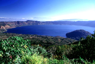
 Coatepeque caldera is seen here from its northern rim, with Santa Ana volcano in the background. The caldera walls rise from 250 m to about 1 km above the lake and the stratigraphy is exposed in some areas. The rounded summit behind the caldera rim to the left is Cerro Verde, which was erupted along a NW-SE-trending fissure cutting through Santa Ana.
 Photo by Lee Siebert, 2002 (Smithsonian Institution).
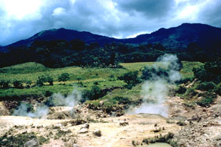
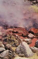 Bubbling mudpools at Ausoles de la Labor fumaroles on the northern flank of Laguna Verde volcano eject reddish oxidized mud onto the surrounding area. This is one of several prominent geothermal areas in the Apaneca Range. Hot springs are also found north of the Apaneca Range, particularly along the Agua Caliente and Escalante rivers.
Photo by Rick Wunderman, 1999 (Smithsonian Institution).
 This view from the road to the Cerro Verde summit shows the eastern side of Coatepeque caldera. The hill in the lake (right) is the Cerro Grande lava dome. The caldera formed during two major explosive eruptions, the first of which occurred about 72,000 years ago, forming the eastern part of the caldera in association with the Arce pumice fall and pyroclastic flow deposits. A lake partially filled the caldera floor prior to the Congo eruption associated with formation of the western part of the caldera.
Photo by Lee Siebert, 2002 (Smithsonian Institution).
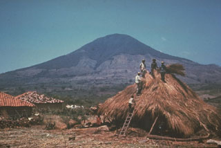
 The dark-colored lava flow in the center of the photo originated during an eruption in 1917 from a vent high on the northern flank of Boquerón volcano (upper right). On June 6, 1917 an eruption began from NW-trending fissures on the upper north flank of Boquerón. A chain of cinder cones formed and a lava flow traveled to the northwest, cutting the railroad between Quezaltepeque and Sitio del Niño. Eruptive activity also occurred at the summit crater of Boquerón, where a small conelet formed on the crater floor. El Picacho peak is at the left.
Photo by Giuseppina Kysar, 1999 (Smithsonian Institution).
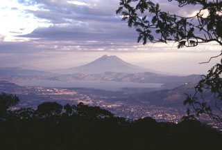 Lake Ilopango occupies the Ilopango caldera immediately east of the capital city of El Salvador, seen in the foreground. This view is from San Salvador volcano with San Vicente volcano in the background. The caldera formed during four major eruptions, the last of which was about 1,500 years ago. This eruption deposited ash and pumice over much of central and western El Salvador.
Photo by Paul Kimberly, 1999 (Smithsonian Institution).
 Conchagua is a conical, but deeply eroded basaltic to basaltic-andesite stratovolcano bordering the Gulf of Fonseca at the SE tip of El Salvador. Cerro de la Bandera, east of Cerro del Ocote, the summit of Conchagua, appears to be younger in age. Recently active fumarolic areas form barren spots on both peaks. Eruptions reported in 1522, 1688, 1868, and 1947 are erroneous, and may refer to landslides associated with earthquakes.
Photo by Gregg Fairbrothers, 1979 (courtesy of Mike Carr, Rutgers University).
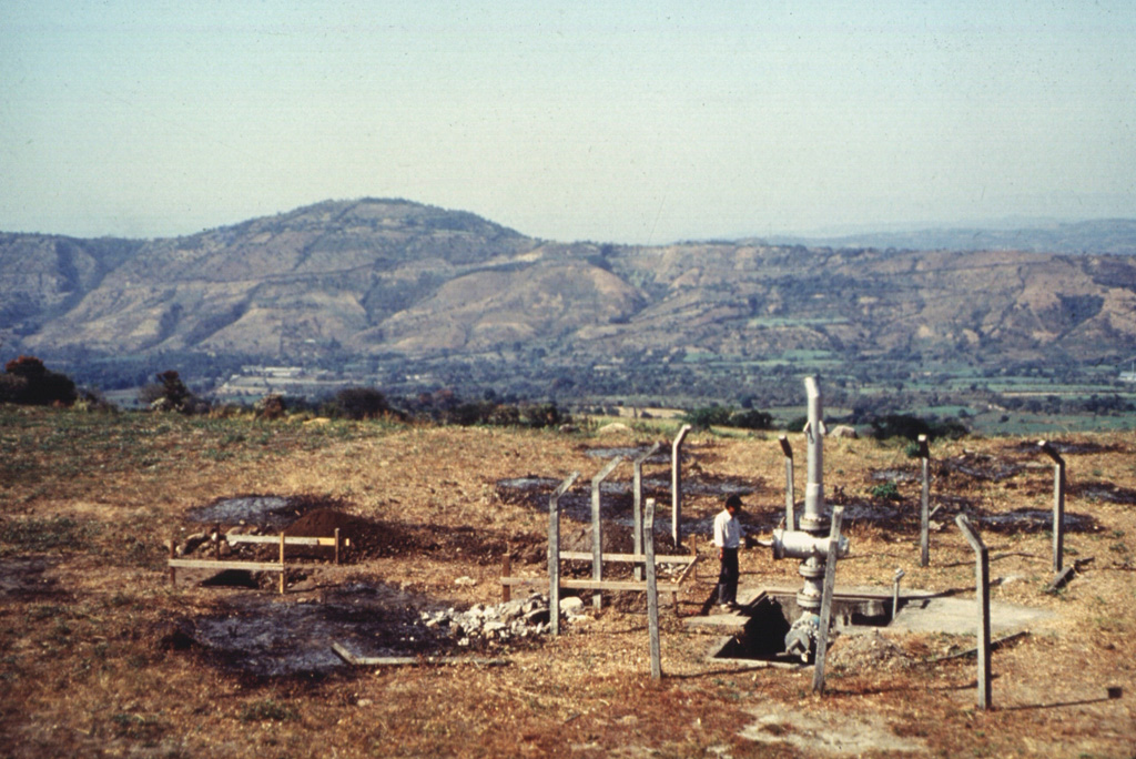
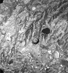 Several maars of the Apastepeque volcanic field are seen in this vertical aerial view. The two lake-filled maars are Laguna de Apastepeque (the light-colored lake at the lower right) and Laguna Chalchuapa (the dark-colored lake at the right-center). SW of it is the large dry maar Hoyo de Calderas, and other dry maars appear at the upper left and lower right. The Pan-American highway cuts across the bottom of the photo, and the town of San Esteban Catarina is at the lower left, immediately west of Cerro Las Delicias lava dome.
 Aerial photo by Instituto Geográfico Nacional El Salvador, 1992.
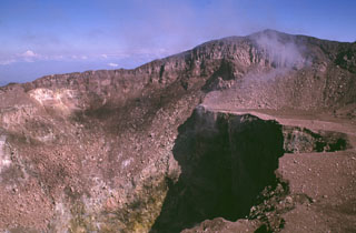
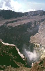
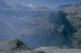
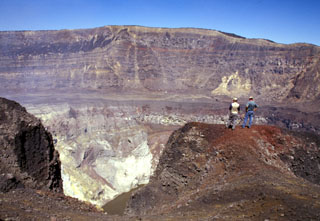 Geologists on the southern rim of Santa Ana's summit crater stand above the hydrothermally altered walls of the more than 100-m-deep inner crater. A near-vertical fault is visible in the far northern wall of the larger crater beyond the crater floor in the center of the photo, above the inner crater. Lava flows exposed in the crater wall are overlain by a roughly 10-m-thick light-brown sequence of phreatomagmatic tephra layers.
Photo by Paul Kimberly, 2002 (Smithsonian Institution).
 San Marcelino scoria cone (center) on the NE flank of Santa Ana was the source of a lava flow that traveled 13 km to the east (left). The 1722 lava flow originated from two vents at the eastern and western sides of San Marcelino.
Photo by Lee Siebert, 2002 (Smithsonian Institution).
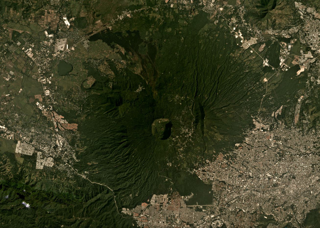
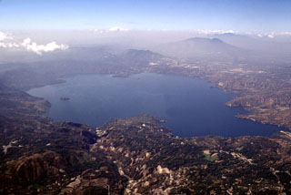
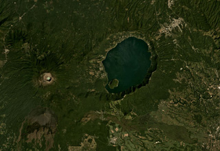
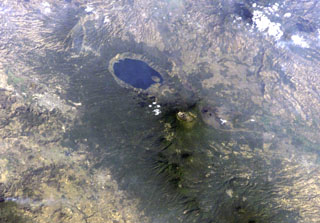 Lake-filled Coatepeque caldera is prominent in this International Space Station image with north to the lower left. A post-caldera lava dome forms an island at the SW side of the lake. The nested summit craters of Santa Ana volcano are visible below and to the right of Coatepeque, and the unvegetated cone of Izalco volcano is to the right of Santa Ana. Small stratovolcanoes of the Sierra de Apaneca form the forested ridge at the bottom right. The light-colored area at the left-center is the city of Santa Ana, the second largest in El Salvador.
NASA International Space Station image ISS004-E-9398, 2002 (http://eol.jsc.nasa.gov/).
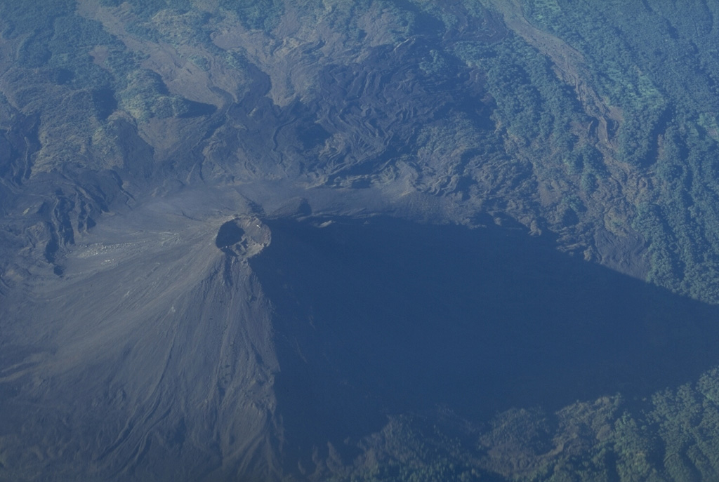
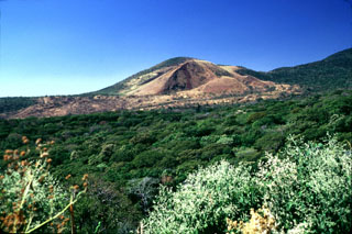
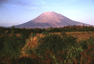
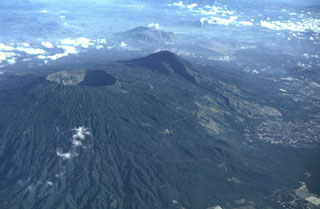
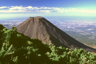 The flanks of Izalco volcano contrast with the vegetated Cerro Verde in the foreground. Izalco rises about 300 m above the saddle separating it from Cerro Verde. This view shows the Pacific Ocean 40 km to the south with much of the area between underlain by deposits associated with a late-Pleistocene Santa Ana debris avalanche.
Photo by Lee Siebert, 2002 (Smithsonian Institution).
 This large lava bomb in the summit crater of San Miguel was probably erupted in 1976. Lava fountaining took place in the central crater, which was active December 2-12, 1976 and February 28 to March 1, 1977, constructing a new spatter cone. Ashfall in December 1976 caused some crop damage.
 Photo by Carlos Pullinger, 1996 (Servicio Nacional de Estudios Territoriales, El Salvador).
 The Ahuachapán geothermal area on the NW flank of Laguna Verde has been used for power generation since 1975. It is one of the most recent manifestations of activity in a group of Pleistocene and Holocene volcanoes comprising the Cuyanausul Range. The Cerro El Aguila and Cerro Los Naranjos volcanoes at the eastern end are Holocene in age. A 1990 steam explosion from the Ahuachapán thermal area resulted in fatalities.
Photo by Dick Stoiber, 1962 (Dartmouth College).
 This view from the southern rim of Coatepeque shows the western side of San Salvador volcano. The broad Boquerón edifice has grown within a large crater within an older stratovolcano, of which rounded Picacho to the left is a remnant. The flat brown-colored area to the right is the 1722 lava flow from San Marcelino scoria cone on the lower flank of Santa Ana.
Photo by Lee Siebert, 2002 (Smithsonian Institution).
 This view shows the western side of Coatepeque caldera (top of the photo) from Cerro Chino scoria cone on the SE flank of Santa Ana, which lies out of view to the left. The caldera rim partially cuts into the eastern side of Santa Ana. The western side of Coatepeque caldera is considered to have formed during the second stage of caldera formation through a lake partially filling the earlier caldera, producing the Congo Formation tephras and pyroclastic flows.
Photo by Lee Siebert, 2002 (Smithsonian Institution).
 This view from the southern crater rim shows the 2030 m high point of San Miguel on the NE rim at the upper right. An ejecta-covered terrace on the eastern side of the crater is truncated by a deep inner crater. The crater morphology has varied dramatically since the beginning of documentation in the 16th century. In 1866 a 600-m-wide, 320-m-deep crater existed in the SE part of the summit crater, while a 100-m-wide, 80-m-deep adventive crater was located in its ENE part.
Photo by Lee Siebert, 1999 (Smithsonian Institution).
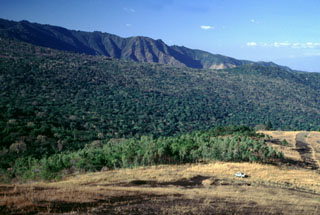
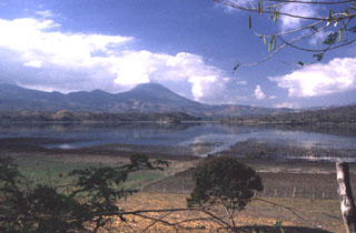
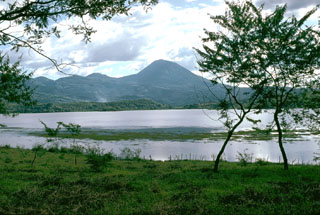
 Volcán de San Diego (upper right) is seen here from the south at the outlet of Lake Güija. The lake formed after lava flows from San Diego blocked the channel of the Desagüe river. Cerro el Tule (left) lies across a narrow channel from the lower flanks of San Diego. Cerro el Tule contains a summit crater and is one of the many cones of the San Diego volcanic field.
 Photo by Giuseppina Kysar, 1999 (Smithsonian Institution).
 Cerro El Chino is seen here from the east, just south of the town of Aguilares and is part of the Cerro Cinotepeque volcanic field, a large group of small Pleistocene-to-Holocene stratovolcanoes and cones constructed along NW-SE-trending faults on either side of the Río Lempa west of Guazapa volcano. The Holocene Cerro Cinotepeque cone lies about 6 km NW of Cerro El Chino.
Photo by Giuseppina Kysar, 1999 (Smithsonian Institution).
 The summit crater of San Miguel volcano reflects a complex sequence of events. This view from the northern crater rim shows two lava benches that are truncated by a deep compound central pit crater from which steam plumes rise. The morphology of the summit crater has varied dramatically during historical time. The inner pit crater has gradually expanded to the east and north and increased in depth to nearly 350 m in 1999.
Photo by Lee Siebert, 1999 (Smithsonian Institution).
 The 13 x 17 km Ilopango caldera is seen here from the NE with the southern caldera wall in the background. It formed during four major Quaternary eruptions, the last of which occurred about 1,500 years ago. The southern caldera wall rises about 500 m above the lake, which had a maximum depth of about 230 m when this photo was taken in 1999.
 Photo by Lee Siebert, 1999 (Smithsonian Institution).
 The SW side of San Miguel volcano towers more than 2000 m above the Pacific coastal plain; the base of the volcano lies only about 100 m above sea level. The symmetrical volcano is one of the most active in El Salvador and has produced dominantly basaltic and basaltic andesite lava flows and tephra. Frequent eruptions have kept much of the upper part of the edifice unvegetated. Flank vents are concentrated on the SE and NW quadrants of the volcano, but have been active during historical time on all sides.
Photo by Lee Siebert, 1999 (Smithsonian Institution).
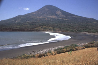 Conchagua volcano towers above sandy beaches along the Gulf of Fonseca at the SE tip of El Salvador. The 1225-m-high stratovolcano has a conical profile, but has been extensively eroded. The easternmost of two major summits, Cerro de la Bandera, is seen in this view from Punta el Chiquirín and appears to be younger in age. Recently active fumarolic areas form barren spots on both peaks of this little-studied volcano. Historical reports of eruptions appear to be erroneous, and may refer to landslides associated with earthquakes.
Photo by Rick Wunderman, 1999 (Smithsonian Institution).
 El Playón scoria cone on the lower NW flank of Santa Ana formed during an eruption in 1658. The eruption began on 3 November 1658, producing ashfall in Comayagua and a lava flow (left) to the NE that surrounded the village of Nejapa. The lava flow in the foreground was emplaced in 1917 from a vent on the upper northern flank of San Salvador.
Photo by Lee Siebert, 2002 (Smithsonian Institution).
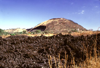
 Scoria deposits are exposed in a quarry on the NE flank of Cerro Verde along the road to its summit. Cerro Verde is the largest of a chain of scoria cones on the SE flank of Santa Ana.
 Photo by Paul Kimberly, 1999 (Smithsonian Institution).
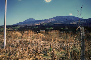
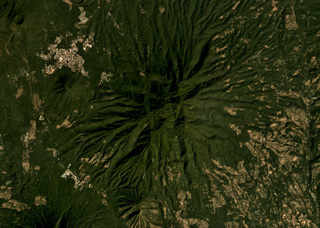
 Guazapa is an eroded Pleistocene volcano NE of the capital city of San Salvador, and is seen here from the SW. There are several relatively young cones and lava flows of similar composition around the lower flanks.
Photo by Carlos Pullinger, 1996 (Servicio Nacional de Estudios Territoriales, El Salvador).
 The western flanks of San Salvador rise above the Zapotitán basin beyond sugar cane fields south of Coatepeque caldera. These flanks and the rounded El Picacho peak left of the summit are part of the ancestral San Salvador volcano. The broad Boquerón edifice subsequently grew over much of the caldera rim, and lava flows traveled down the northern and southern flanks, smoothing its profile.
 Photo by Lee Siebert, 2002 (Smithsonian Institution).
 Cerro Juana Pancha, seen from the south near the Pan-American highway on the way to La Unión, is part of the Pleistocene Cerro Yayantique volcanic field. Cerro Yayantique is the most prominent and least-eroded feature in a broad area of Pleistocene volcanic rocks in the SE corner of El Salvador west of the NW arm of the Gulf of Fonseca. An E-W-trending area of smaller Pleistocene volcanic cones to the NE straddles both sides of the Río Amatillo Sirama.
Photo by Giuseppina Kysar, 1999 (Smithsonian Institution).
 The summit of San Miguel volcano contains a deep crater whose morphology has been frequently modified by historical eruptions. In 1586 the volcano already had a truncated summit; before then the volcano was said to have had a sharp peak. In 1866 the crater was 600 m wide and 320 m deep and contained a subcrater on the ENE side. A cinder cone that formed at the NE side of the crater in 1884 had largely disappeared by 1924, and a ring plain on the crater floor was largely gone by 1949.
Photo by Dick Stoiber, 1965 (Dartmouth College).
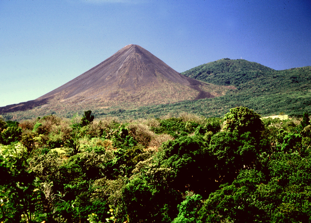
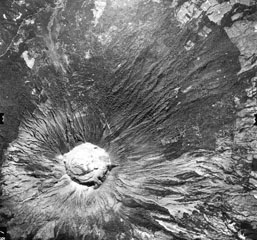
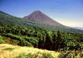
 Izalco volcano was once known as the "Lighthouse of the Pacific" for its persistent incandescent nighttime eruptions. It was constructed on the southern flank of Santa Ana, whose broad summit is to the left. To the right is Cerro Verde, a scoria cone on the SE Santa Ana flank. Lava flows at the base if Izalco from both summit and flank vents and extend out to 7 km.
Photo by Lee Siebert, 1999 (Smithsonian Institution).
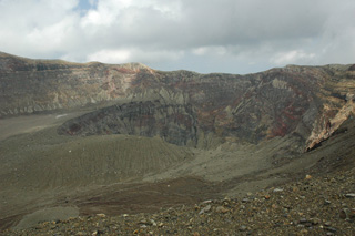 The Santa Ana crater is seen here from the western rim in 2011. Several nested craters have formed across the summit, with a crater lake in the smallest crater in the center of this photo (out of view). Exposed in the crater walls are lava flows and explosive eruption deposits that form the edifice.
 Photo by Lis Gallant, 2011.
 The lava flow in the foreground was erupted in 1722 from San Marcelino, the scoria cone to the right. The 13-km-long Teixcal lava flow traveled to the east and destroyed San Juan Tecpan village. The flow originated from two vents on opposite sides of San Marcelino. Cerro Chino is to the left of San Marcelino and is the central of three scoria cones along a SW trend from San Marcelino to La Olla.
Photo by Lee Siebert, 1999 (Smithsonian Institution).
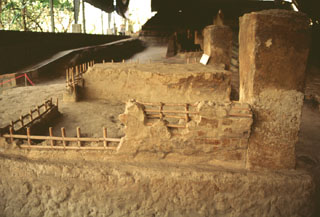 An archeological excavation near the community of Cerén has unearthed several small Protoclassic Mayan homesteads that were buried by an eruption from the nearby Laguna Caldera scoria cone on the northern flank of San Salvador. The eruption occurred suddenly, as seen from the remains of uneaten meals left by occupants who fled their houses. The eruption was radiocarbon dated at about 590 CE.
Photo by Rick Wunderman, 1999 (Smithsonian Institution).
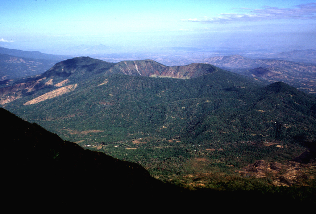
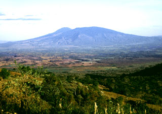
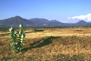
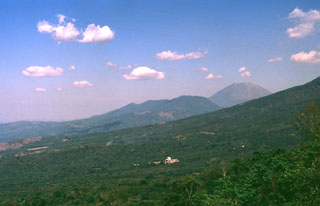 The Chinameca volcanic complex is seen here from the west beyond the lower flank of Pleistocene El Tigre volcano. The lower peak at the right side of the Chinameca complex is Cerro el Limbo, a cone on the western flank of Chinameca caldera. The higher peak at the upper right is San Miguel volcano, which is separated by a low saddle from Chinameca.
Photo by Carlos Pullinger, 1994 (Servicio Nacional de Estudios Territoriales, El Salvador).
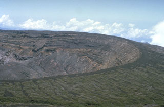
 The broad summit of Santa Ana is seen here from Cerro Verde, a cone on its SSE flank. The summit has a series of four nested craters, the largest of which is 1.5 km wide. Houses of Hacienda San Blas are visible at the bottom of the photo. Much of the flanks are covered with coffee crops that are an important part of the local economy.
Photo by Carlos Pullinger, 1996 (Servicio Nacional de Estudios Territoriales, El Salvador).
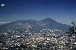 San Salvador volcano rises above the capital city of El Salvador. The broader peak to the left is the Boquerón edifice, which has grown within the 6-km-wide crater of the older El Picacho edifice (the peak to the right). Most of the four pre-1917 eruptions recorded at San Salvador since the 16th century have occurred at flank vents.
Photo by Rick Wunderman, 1999 (Smithsonian Institution).
 The largest peak on the El Salvador/Guatemala border is Volcán Chingo, seen here from the SW on the shores of Laguna de Llano on the Salvador side of the border.
Photo by Giuseppina Kysar, 1999 (Smithsonian Institution).
 Cerro Verde is seen here from the NW above Hacienda San Blas. Three N-S-trending craters are located at the summit of Cerro Verde, and a fourth is located on the SE flank of the cone.
Photo by Kristal Dorion, 1994 (U.S. Geological Survey).
 The fresh-looking lava flow at the upper right on the north flank of San Miguel volcano was emplaced during an eruption in 1844. The flow originated on July 25 from a NNW-flank fissure and traveled initially to the NNW before diverting to the NE and reaching to 8 km from the summit. After December the volcano began long-term explosive activity that lasted until 1848, when another lava flow occurred.
Photo by Kristal Dorion, 1994 (U.S. Geological Survey).
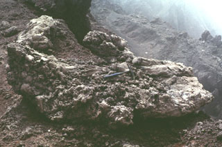
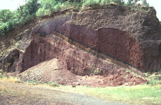
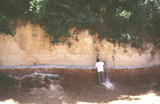
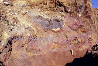 Multi-colored remnants of Santa Ana volcano are exposed in a quarry wall in a hummock of the Acajutla debris avalanche deposit with a geologist to the lower right for scale. This quarry in Cerro el Jicaro, 6 km SE of the city of Sonsonate, displays characteristic textures of debris avalanche deposits. Individual segments are faulted and slightly deformed, but retain their integrity despite being transported about 18 km from the volcano.
 Photo by Paul Kimberly, 1999 (Smithsonian Institution).
 The rounded Volcan Taburete (far left) and the Tecapa volcanic massif rise to the NW above the Pacific coastal plain of El Salvador. The small Loma Pacha cone on the lower SE flank of Taburete (visible in the center of the image) produced a thick lava flow that traveled to SE. The rounded peak to the far right is Cerro Oromontique, a cone that erupted on the flank of El Tigre.
Photo by Lee Siebert, 1999 (Smithsonian Institution).
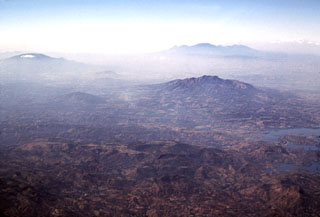
 The 8 x 11 km wide Ilopango caldera fills the center of the image in this view from the ESE. Fresh, light-colored exposures of the Tierra Blanca Joven formation in the foreground associated with the latest caldera-forming episode were in part created by landslides during the January 2001 earthquake. The capital city of San Salvador lies beyond the lake, in front of San Salvador volcano (upper right). The Santa Ana volcanic complex lies beyond San Salvador volcano in the background to the far right.
Photo by Lee Siebert, 2002 (Smithsonian Institution).
 Several different features of the Apastepeque volcanic field can be seen in this view from the Hoyo de Calderas crater rim. Two lava domes are seen in the distance to the left, Cerro Las Delicias and Cerro Santa Rita (far left). The larger volcano in the haze behind Cerro Santa Rita is San Vincente.
Photo by Giuseppina Kysar, 1999 (Smithsonian Institution).
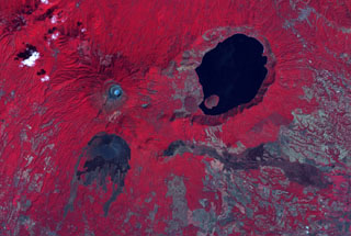 The summit crater complex of Santa Ana volcano with its small light-bluish crater lake is visible at the left-center in this false-color ASTER satellite image (N is to the top; this image is approximately 30 km across). The lake-filled Coatepeque caldera is east of Santa Ana, and Izalco volcano with its lava flows are to the south. A fissure was the source of an eruption in 1722 CE from a scoria cone (center) on the SE flank that produced the lava flow across the image to the lower right.
NASA ASTER image, 2001 (https://earthobservatory.nasa.gov/).
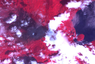 The summit crater complex of Santa Ana volcano with its small crater lake is visible left of center in this NASA ASTER image (with north to the top) taken on October 10, 2005, following an explosive eruption on October 1. In this false-color image dark ashfall deposits cover otherwise reddish vegetation around the summit of the volcano and extend down its upper eastern flank. The eruption occurred just prior to heavy rainfall accompanying Hurricane Stan, and lahars swept the flanks of the volcano. The large lake at the right is Coatepeque caldera.
 NASA ASTER image, 2005 (https://earthobservatory.nasa.gov/).
 The eroded El Tigre volcano is in the center of this December 2019 Planet Labs satellite image monthly mosaic (N is at the top; this image is approximately 13.5 km across). The eroded cones of Cerro Oromontique and La Manita are below the western and southern flanks, respectively, and the Cerro Alegria crater is in the NW corner of this image.
Satellite image courtesy of Planet Labs Inc., 2019 (https://www.planet.com/).
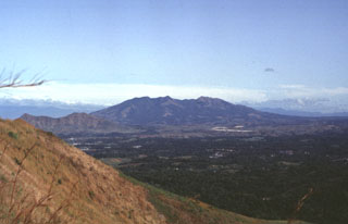
 Volcán de Guazapa (near the center) rises beyond the Cerrón Grande reservoir (lower right) in this view from the NE. The smaller cone to the left of Guazapa is Cerro Tecomatepe. San Salvador volcano is to the upper left, the Santa Ana complex is the broad massif at the upper right, and peaks of the Sierra Apaneca near the Guatemalan border form the irregular ridge to the far right.
Photo by Lee Siebert, 2002 (Smithsonian Institution).
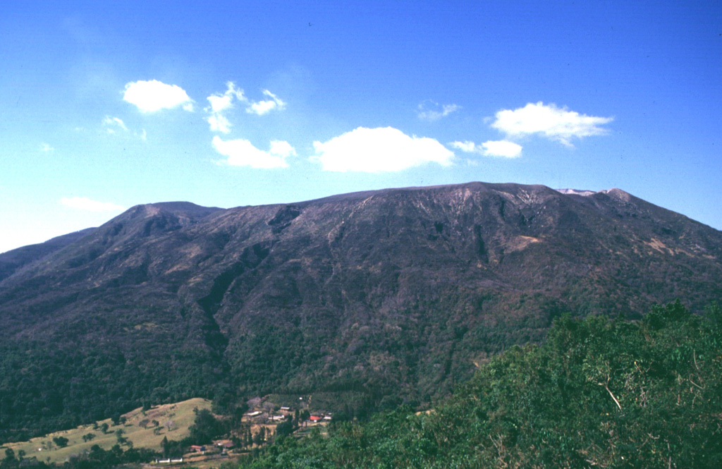
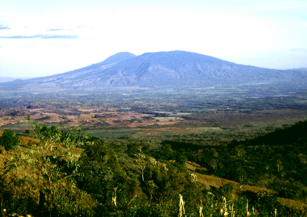
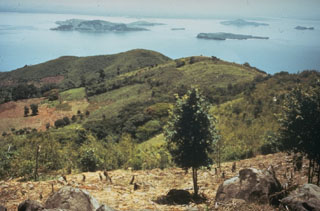
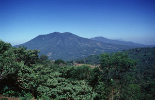
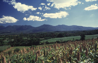 The northern side of the broad Apaneca Range is seen here from El Rodeo. From left to right are Cerro Cuyanausul, Laguna Verde (the center peak), Las Ninfas, and the Cerro La Cumbre complex. The E-W-trending chain of overlapping Pleistocene and Holocene volcanoes of the Apaneca Range forms a major topographic barrier in western El Salvador.
Photo by Carlos Pullinger, 1996 (Servicio Nacional de Estudios Territoriales, El Salvador).
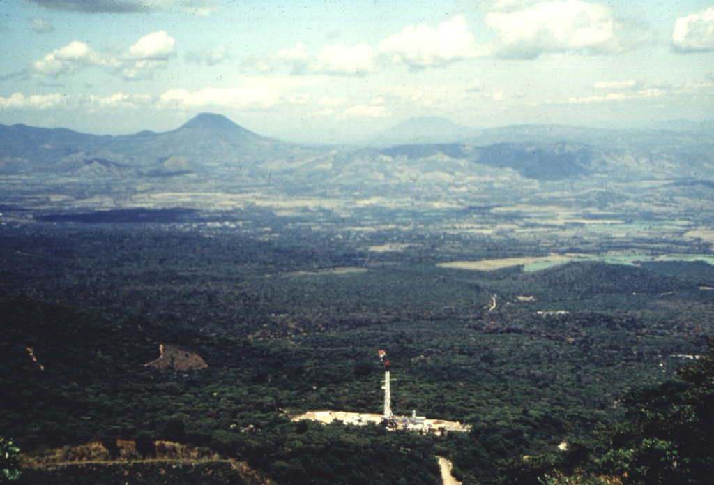
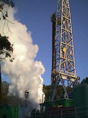
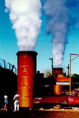 Steam pours from twin silencer towers at the Berlín 2 geothermal site. Geothermal fluids can flow from a well at the speed of sound, which resembles that of a jet engine to the field crew. The silencer drops the sound to a dull roar. Two 25 MW power plants came on line at Berlín 2 in 1998 and 1999. The two plants utilize both production and reinjection wells, and were expected (after operating and financial expenses) to save $56,000 in fuel costs per day.
Photo courtesy of Comisión Ejecutiva Hidroeléctricia del Río Lempa (CEL), 1992.
 Guazapa is seen here from the west, 3 km NE of the town of Guazapa. This eroded Pleistocene cone is one of the largest of the interior valley of El Salvador. Deep erosional valleys have formed down the flanks, and younger cones and lava flows are found around its base.
Photo by Giuseppina Kysar, 1999 (Smithsonian Institution).
 This view to the east across the main El Salvador volcanic front shows San Vicente volcano in the foreground and Tecapa, El Tigre, and Usulután volcanoes to the upper right. The small cone in the saddle between Usulután and El Tigre is Cerro Oromontique. Behind Tecapa and El Tigre is conical San Miguel, and to its right in the far distance is Conchagua volcano.
Photo by Lee Siebert, 1999 (Smithsonian Institution).
 Sequences of phreatomagmatic tephra layers are exposed in the southern and western crater walls of Santa Ana. The hydrothermally altered area to the lower right is the inner crater, which contains an acidic lake not visible in this photo. Four crater walls can be seen in this photo; the two outer walls appear in the center on and below the horizon, beyond the flat rim of the inner crater.
Photo by Lee Siebert, 2002 (Smithsonian Institution).
 The symmetrical cone of San Miguel is truncated by a deep, 900-m-wide crater. Benches on the crater floor reflect a complex history of modification of the crater during historical time. The upper unvegetated part of San Miguel volcano is dissected by erosional gullies. Many lava flows have originated from flank vents, including those at the lower right and the dark-colored, sparsely vegetated flow crossed by the highway at the upper left. The latter was erupted in 1844.
Aerial photo by Instituto Geográfico Nacional El Salvador.
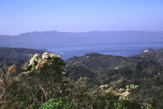
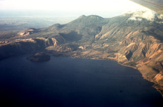
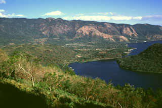
 Lago de Coatepeque fills the eastern side of Coatepeque caldera. Post-caldera lava domes, including the rounded island of Cerro Grande at the far, left side of the lake, were erupted along a E-W-trending line. The rounded hill beyond the caldera and to the right is Cerro Verde.
Photo by Lee Siebert, 2002 (Smithsonian Institution).
 An aerial view of the western side of Coatepeque caldera shows Cerro Grande lava dome, the island to the left. On the ridge behind the caldera wall are (from left to right) the San Marcelino-Cerro la Olla and Cerro el Conejal-Cerro el Astillero complexes, the summit of Izalco volcano, rounded Cerro Verde scoria cone, and (in the clouds) the summit of Santa Ana volcano. The Pacific Ocean is visible in the distance.
Photo by Bill Rose, 1967 (Michigan Technological University).
 The broad E-W-trending Apaneca Range is seen here from the south with flat-topped Cerro de Apaneca on the left. The Laguna Las Ninfas -Laguna Verde complex is in the center, and to its right are Cerro Cuyanausul, Cerro los Ranas, Cerro el Aguila, and Cerro los Naranjos. The Concepción de Ataco caldera lies beyond the center horizon, behind post-caldera cones. The photo is taken from the top of a hummock on the surface of the massive Acajutla debris avalanche deposit that originated from Santa Ana volcano, which is out of view to the right.
Photo by Lee Siebert, 1999 (Smithsonian Institution).
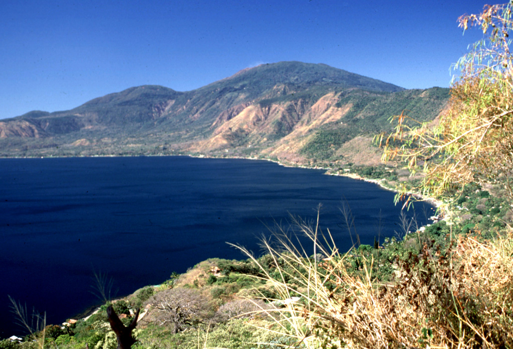
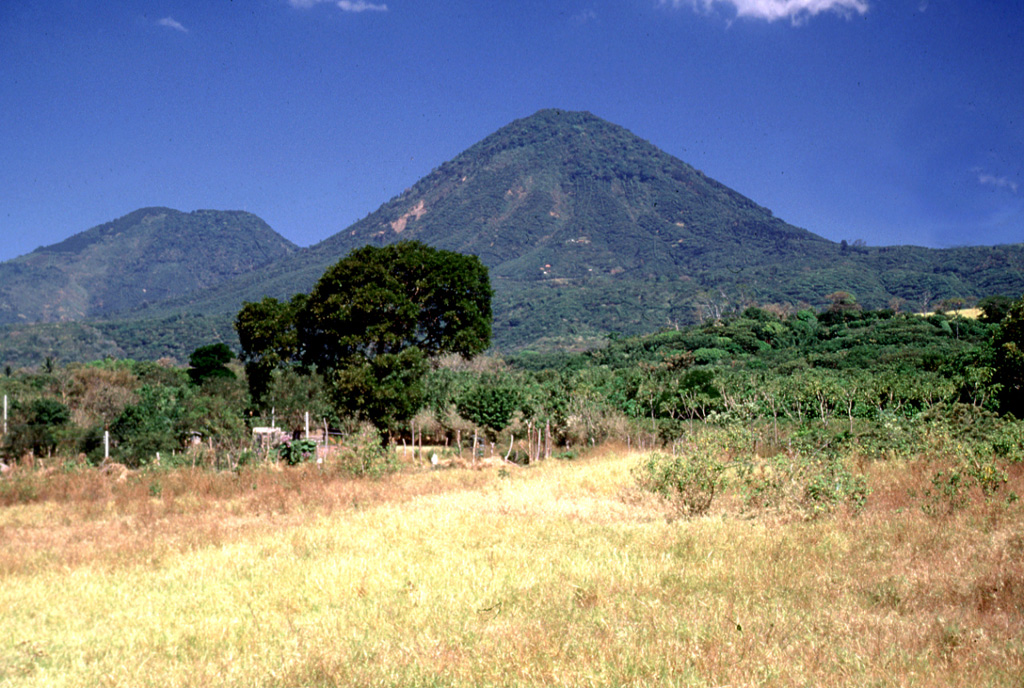
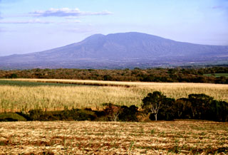
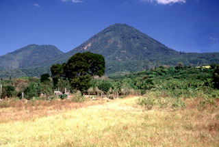
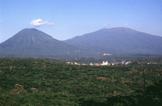 Two volcanoes rise above the town of Juayua in western El Salvador. The peak to the left is Cerro los Naranjos, one of the youngest peaks of the Apaneca Range volcanic complex. The broader peak to the right is Santa Ana. Santa Ana has produced recent eruptions from both summit and flank vents.
Photo by Carlos Pullinger, 1996 (Servicio Nacional de Estudios Territoriales, El Salvador).
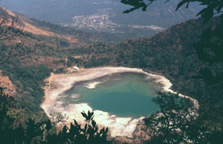
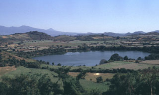 The Apastepeque volcanic field NE of San Vicente volcano consists of a dense cluster of about two dozen lava domes, scoria cones, and maars. Laguna de Apastepeque is seen here from the WNW with the Tecapa-San Miguel volcano group in the background. The visible walls of the 800-m-wide lake are only about 5 m high and the lake is approximately 50 m deep.
Photo by Carlos Pullinger, 1996 (Servicio Nacional de Estudios Territoriales, El Salvador).
 A drill rig towers above a well site at the Berlín geothermal area. The first exploratory well at Berlín was drilled in 1966 by the government of El Salvador, with assistance from the United Nations. Feasibility studies in the early 1980s were halted by the civil war, and production testing of wells was not completed until 1987. The first two 5 MW power plants came on line in 1992, and 25 MW wells at the Berlín 2 site went into operation in 1998 and 1999.
Photo courtesy of Comisión Ejecutiva Hidroeléctricia del Río Lempa (CEL).
 Islands dot the Gulf of Fonseca in this NE-looking view from Cerro el Havillal on Isla Conchagüita. Isla Conchagüita is a small, 4-km-wide island across a narrow strait from Conchagua volcano. Late-stage eruptions formed a small, sharp-topped cone with a 100-m-wide summit crater at the southern end of the island. A crescent-shaped crater open to the west is located at the northern end of the island.
Photo by Tom Crafford, 1973 (Dartmouth College, courtesy of Dick Stoiber).
 A lake fills the youngest of four nested craters of Santa Ana volcano (top center). A road winds at the lower right to radio antennas at the summit of forested Cerro Verde cinder cone, one of a series of volcanic cones constructed along a NNW-SSE-trending fissure cutting across Santa Ana. The dark unvegetated areas at the bottom of the photo are the northern flanks of Izalco volcano.
Aerial photo by Instituto Geográfico Nacional El Salvador, 1996.
 Scoria from the 1904 eruption of Santa Ana form the darker deposits across the summit crater rim. The first of two 20th-century eruptions from Santa Ana began on 12 January, lasted for about two weeks, and included phreatomagmatic explosions.
Photo by Carlos Pullinger, 1996 (Servicio Nacional de Estudios Territoriales, El Salvador).
 The SW part of Coatepeque caldera was formed about 57,000 years ago following the eruption of the roughly 16 km3 Congo biotite-bearing rhyolitic pumice fall and pyroclastic flow deposits. Plinian and phreatoplinian eruptions took place through a lake that formed in the NE part of the caldera that formed during the larger Arce eruption about 72,000 years ago.
Photo by Lee Siebert, 1999 (Smithsonian Institution).
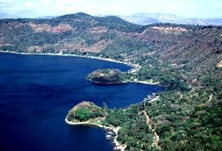 The Los Anteojos lava domes form small peninsulas on the eastern shore of Lago de Coatepeque. Four other domes are on the opposite side of the caldera in a trend that passes through Izalco volcano to the SW. The Anteojos domes are mostly submerged, rising only about 20-25 m above the lake surface in this 2002 photo. A chain of scoria cones was erupted along caldera ring faults; two of these are seen beyond the two domes.
Photo by Lee Siebert, 2002 (Smithsonian Institution).
 Young lava flows from Volcán de San Diego (left center) extend into Lake Güija (lower left). The prominent cinder cone on the lake shore directly south of Volcán de San Diego is Cerro el Tule. Young basaltic lava flows from other vents of the San Diego volcanic field in western El Salvador, such as Cerro la Vega de la Cana and Loma Iguana (upper left), extend into both Lake Güija and Laguna de Metapán at the top of the photo. The cinder cone north of Volcán de San Diego (surrounded by older lava flows) is Cerro Masatepeque.
Aerial photo by Instituto Geográfico Nacional El Salvador, 1977.
 Volcán Chingo, located along the Guatemala/El Salvador border, is the second highest of a group of volcanoes in SE Guatemala. It is seen here from the Guatemalan side above Laguna Atescatempo, which was created when lava flows from the Volcán Chingo area dammed local drainages. Many basaltic scoria cones are located on the flanks on both sides of the border.
Photo by Lee Siebert, 1993 (Smithsonian Institution).
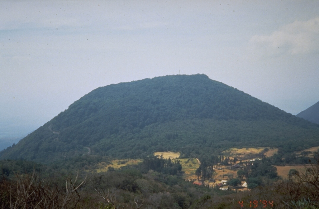
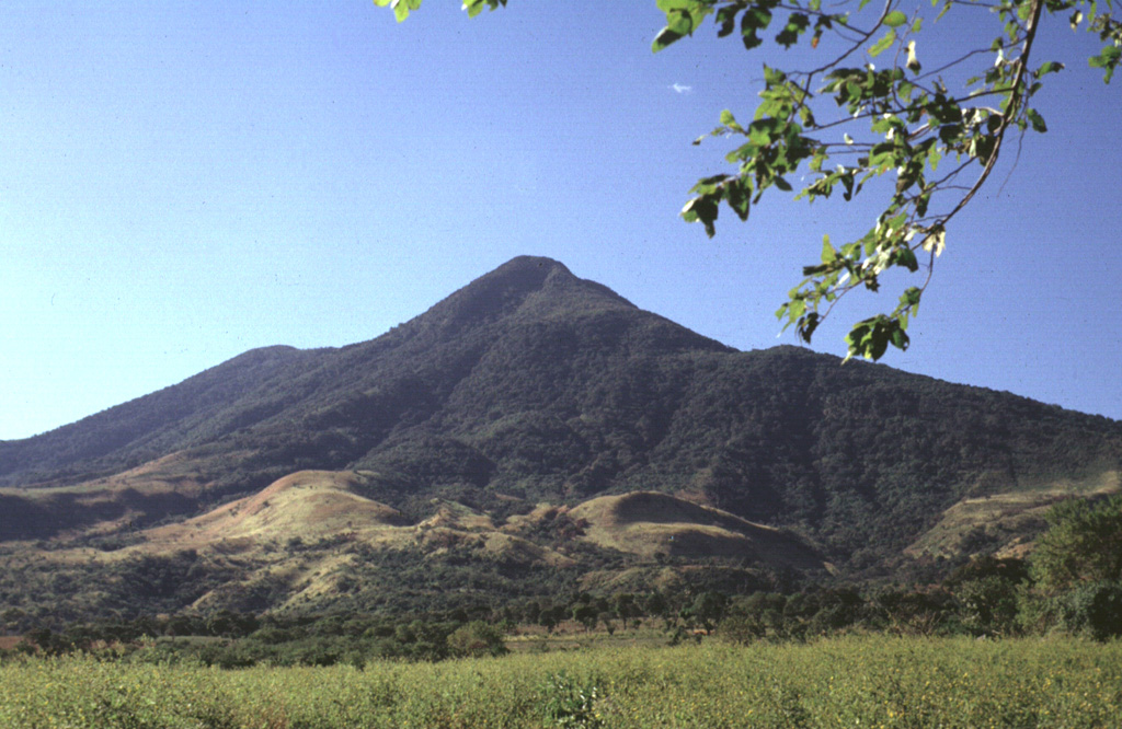
 Cerro los Naranjos volcano is at the SE end of the Sierra de Apaneca. Cerro el Aguila ("Eagle Peak") lies on the left horizon to the NW of Los Naranjos.
Photo by Lee Siebert, 2002 (Smithsonian Institution).
 Izalco towers above the western flanks of Santa Ana, which are covered in coffee crops. Izalco erupted in a cornfield on the southern flanks of Santa Ana in 1770 and grew 650 m above the vent over the following two centuries. Despite its proximity to Santa Ana, Izalco lavas are distinctly higher in aluminum, calcium, and strontium. Recent eruptions of Izalco are more similar to Santa Ana than earlier ones.
Photo by Lee Siebert, 2002 (Smithsonian Institution).
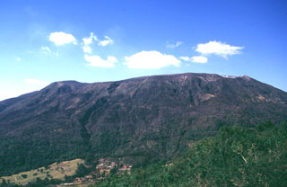
 Chinameca is a small stratovolcano with a roughly 2-km-wide summit caldera, is seen here from San Miguel volcano to its SE. The Holocene Cerro el Limbo cone (left) is on the western flank, and a Holocene lava flow extends to the north from a vent on the NNW flank. The small peak on the far-right flank is Cerro Partido.
Photo by Kristal Dorion, 1994 (U.S. Geological Survey).
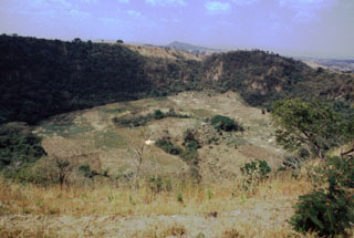 Hoyo de Caldera is a maar crater located NW of Laguna de Apastepeque. The crater is 700 m wide and 140 m deep, seen here from the SE in 1999.
 Photo by Giuseppina Kysar, 1999 (Smithsonian Institution).
 Laguna de Alegría is seen here from the summit of Tecapa volcano, looking SE with the town of Santiago de María in the background. The 600-m-wide crater lake lies about 300 m below the summit in this 1994 photo. Santiago de María is at the eastern end of the Tecapa volcanic complex, on the 900-m-high saddle between it and Cerro El Tigre volcano. Cerro Oromontique, on the flank of El Tigre volcano rise immediately to the right of the town.
Photo by Carlos Pullinger, 1994 (Servicio Nacional de Estudios Territoriales, El Salvador).
 Cerro Masahuat is an eroded Pleistocene stratovolcano that was constructed SW of the San Diego volcanic field in western El Salvador. The 1005-m-high volcano is seen here from the north and is surrounded on three sides by the Río Lempa, which lies beyond the ridge in the foreground.
Photo by Giuseppina Kysar, 1999 (Smithsonian Institution).
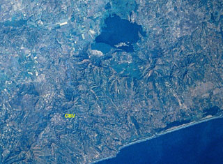 Cerro Buena Vista (CBV) is an eroded Pleistocene stratovolcano located in the Jucuarán Range in the SE corner of El Salvador. The Jucuarán Range consists primarily of Pliocene volcanic rocks of the Bálsamo Formation. The 750-m-high Cerro Buena Vista volcano lies about 10 km north of the Pacific coast and SW of Laguna de Olomega, the 6-km-wide lake at the top-center. A broad crater at Cerro Buena Vista roughly 1 km wide is breached to the WSW. North is to the upper left in this NASA Space Shuttle Image.
NASA Space Shuttle image STS61C-31-47, 1986 (http://eol.jsc.nasa.gov/).
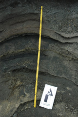 This outcrop within a barranca (ravine) on the western side of the Santa Ana summit area shows explosive deposits from the 2005, 1904, and older eruptions. The different ash and lapilli units have variable grain sizes, an indication of variations in explosivity. The yellow ruler is 72 cm long; photo taken in 2011.
Photo by Lis Gallant, 2011.
 The 7 x 10 km lake-filled Coatepeque Caldera formed 72 ka and is shown in this November 2019 Planet Labs satellite image monthly mosaic (N is at the top; this image is approximately 25 km across). The western caldera rim formed on the Santa Maria eastern flank, and several lava domes formed in the SW area with Cerro Grande forming the island within the lake. Santa Ana with its blue-green crater lake and Izalco with the unvegetated slopes are W and SW, respectively.
Satellite image courtesy of Planet Labs Inc., 2019 (https://www.planet.com/).
 A volcanologist investigates an exposure of the Arce deposits on the eastern flank of Chilamatal caldera, about 10 km ENE of the rim of Coatepeque caldera. The Arce eruption around 72,000 years ago produced about 40 km3 of tephra and was associated with the first caldera-forming event at Coatepeque. The Arce deposits consist of two thick biotite-rich pumice fall deposits, separated by thin tephra deposits containing ash, pumice, and lithics. These ashfall deposits are distributed over much of western El Salvador.
Photo by Carlos Pullinger, 1996 (Servicio Nacional de Estudios Territoriales, El Salvador).
 The 1.5-km-wide Boquerón crater formed during a major eruption about 1200 CE. The eruption produced a 0.3-0.5 km3 San Andrés Talpetate Tuff that went primarily to the west, and was accompanied by pyroclastic flows. The eruption was named after the San Andrés archaeological site, where it was first identified. The outskirts of the city of San Salvador extend up the flank to the right.
Photo by Carlos Pullinger, 1996 (Servicio Nacional de Estudios Territoriales, El Salvador).
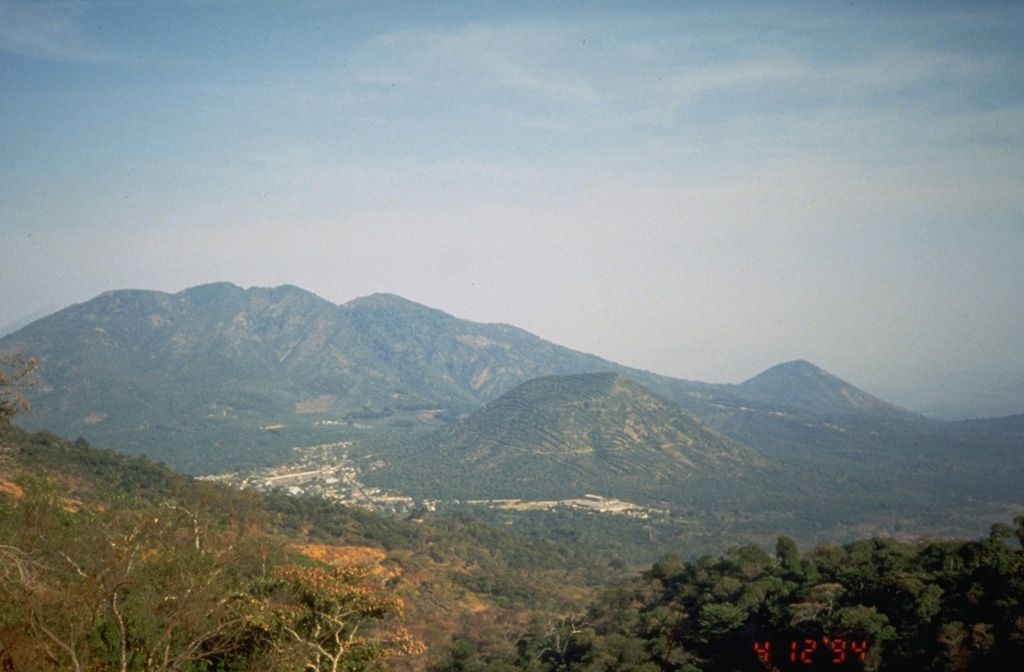
 A westward view down the axis of a cluster of volcanoes between San Miguel and San Vicente volcanoes shows the eroded Pleistocene Cerro el Tigre volcano to the left and Tecapa to its right. San Vicente volcano is in the distance to the far-right.
Photo by Carlos Pullinger, 1996 (Servicio Nacional de Estudios Territoriales, El Salvador).
 The broad summit of Santa Ana volcano has a 1.5-km-wide crater seen here from the south. The series of bedded phreatomagmatic tephra layers exposed in the crater wall in this photo form the summit region and overlie lava flows exposed lower in the crater walls.
Photo by Dick Stoiber, 1966 (Dartmouth College).
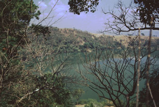 Laguna Chalchuapán is one of several maars in the Apastepeque volcanic field. The 700-m-wide crater is located immediately NE of the Hoyo de Calderas crater. Lahar deposits underlie pumice deposits exposed in the crater walls.
 Photo by Giuseppina Kysar, 1999 (Smithsonian Institution).
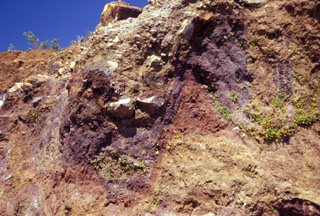 Multi-colored individual units of the Acajutla debris avalanche deposit are offset along normal faults in this view of a quarry wall 6 km SE of the city of Sonsonate. Many blocks are unfractured, and some are shattered blocks with jigsaw textures. About 8 m of the quarry wall is exposed on the right-hand side. The voluminous Acajutla avalanche deposit was produced by late-Pleistocene edifice failure of Santa Ana; this quarry lies about 18 km from the volcano.
Photo by Lee Siebert, 2002 (Smithsonian Institution).
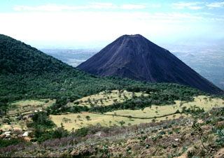 Izalco volcano rises beyond the Cerro Verde flank to the left, as seen from the trail to the summit of Santa Ana. Hotel de la Montaña was constructed at the summit of Cerro Verde to provide a view of the Izalco erupting, which occurred frequently since 1770. By the time the hotel was completed, the eruption of Izalco had ended.
Photo by Lee Siebert, 2002 (Smithsonian Institution).
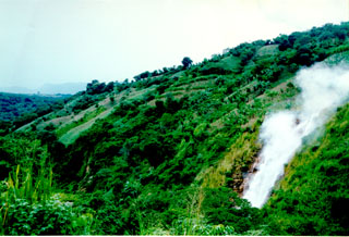 Steam rises above El Tronador, a fumarole along the lushly vegetated slopes of the Berlín geothermal area. The steam has temperatures of 105-107°C and begins condensing within 5 m of the vent. The intensity of geothermal activity at Tecapa has been stable during historical time.
Photo courtesy of Comisión Ejecutiva Hidroeléctricia del Río Lempa (CEL).
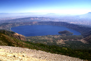 The 7 x 10 km Coatepeque caldera is seen here from the Santa Ana summit. The caldera formed during a series of major explosive eruptions between about 70,000 and 57,000 years ago. Post-caldera eruptions included the formation of basaltic scoria cones and lava flows near the western margin of the caldera and the extrusion of lava domes, including Cerro Grande, the island in the W side of the caldera lake.
Photo by Lee Siebert, 2002 (Smithsonian Institution).
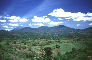 Chinameca volcano in the distance contains a 2-km-wide caldera, seen here from the north with the summit of San Miguel behind it to the left. A cluster of geothermal fields is located on the northern flank, surrounding the city of Chinameca.
Photo by Carlos Pullinger, 1996 (Servicio Nacional de Estudios Territoriales, El Salvador).
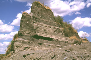 A quarry at Laguna de Aramuaca exposes a roughly 10-m-high section of thinly bedded pyroclastic-surge layers. Despite its immediate proximity to the Pan-American highway, this spectacular maar remains to be studied in detail.
Photo by Lee Siebert, 1999 (Smithsonian Institution).
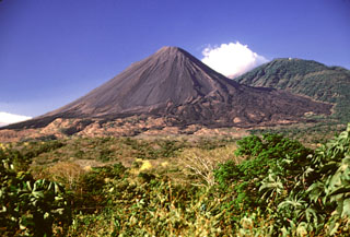 A lava flow field is at the base of Izalco composed of flows that mostly erupted from flank vents. They were deflected by the flank of Santa Ana and extend as far as about 7 km from the Izalco summit. The vegetated Cerro Verde scoria cone is to the right and is part of a trend of cones and vents that erupted SE of Santa Ana.
Photo by Lee Siebert, 2002 (Smithsonian Institution).
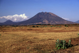 Usulután rises above the Pacific coastal plain at the SE end of a cluster of volcanoes between San Vicente and San Miguel. Several valleys have formed on the flanks of, including the one seen in this view of the SW flank. The rounded peak to the left is Cerro Oromontique on the flank of El Tigre volcano.
Photo by Lee Siebert, 1999 (Smithsonian Institution).
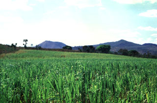 Cerro Redondo on the left and Picudo on the right are seen from the east across fields between the towns of Guazapa and Aguilares. These Pleistocene cones are part of the Pleistocene-to-Holocene Cerro Cinotepeque volcanic field.
Photo by Giuseppina Kysar, 1999 (Smithsonian Institution).
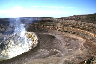 Several nested craters are found at the summit of Santa Ana. Gases rise from fumaroles on the steep NE wall of an inner crater, within a roughly 900-m-wide crater. The 80-m-high crater walls expose tephra layers from phreatomagmatic eruptions. The walls of the two outer craters, which open towards the SW, are at the upper right.
Photo by Lee Siebert, 2002 (Smithsonian Institution).
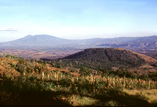 Cerro Alto (right) is a scoria cone on the SE flank of Coatepeque caldera, seen here from the southern caldera rim. Basaltic lava flows were erupted from the eastern side of the cone. Cerro Alto predates the formation of Coatepeque caldera and is overlain by deposits from the caldera-forming eruptions. San Salvador volcano is on the horizon to the east (left).
Photo by Lee Siebert, 2002 (Smithsonian Institution).
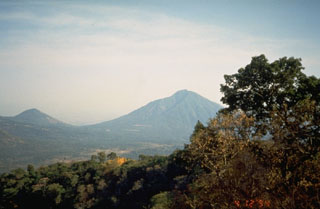 Usulután (right) is at the SE end of a cluster of volcanoes west of San Miguel volcano. La Manita (left) a small cone to the NE of Usulután on the flank of El Tigre has also been mapped as Holocene in age, along with Cerro Nanzal, a cone on the SE flank of Usulután.
 Photo by Kristal Dorion, 1994 (U.S. Geological Survey).
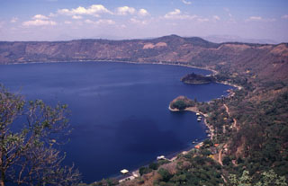 The Anteojos lava domes form peninsulas on the eastern shore of Lake Coatepeque, most of which lie beneath the lake surface. Four other domes formed in the opposite side of the caldera along a trend that passes through Izalco volcano to the SW. Two scoria cones on the horizon erupted along caldera ring faults.
Photo by Carlos Pullinger, 1996 (Servicio Nacional de Estudios Territoriales, El Salvador).
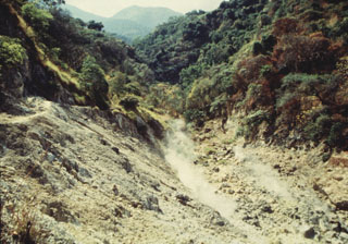 Fumaroles are seen here within Ausoles de Agua Agria, a large thermal area on the flank of San Vicente. Low-temperature fumaroles (less than 100°C) and hot springs are located along faults through the northern and western flanks.
Photo courtesy of Comisión Ejecutiva Hidroeléctricia del Río Lempa (CEL), 1992.
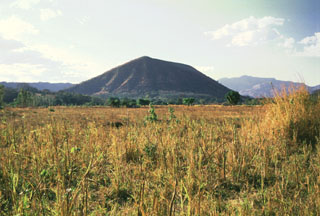 Cerro Singüil is a large scoria cone with a summit crater that lies at the eastern end of a large volcanic field in the interior valley of El Salvador near the Guatemalan border, SE of Volcán Chingo. Cerro Singüil is seen here from the SE along the Pan-American Highway, around the eastern flank of the cone.
Photo by Giuseppina Kysar, 1999 (Smithsonian Institution).
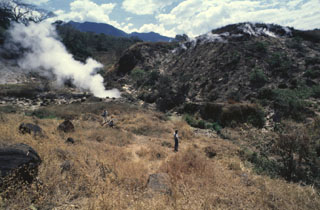 Ausoles de la Labor geothermal field on the flank of Laguna Verde volcano is within the Ahuachapán geothermal field. The fumaroles typically attain temperatures of about 100°C. In addition to those at La Labor, fumaroles are also located at El Playón, Agua Shuca, El Sauce, and higher up at Laguna Verde and Ausoles de Cuyanausul, and numerous hot springs are found in the Ahuachapán geothermal area.
 Photo by Giuseppina Kysar, 1999 (Smithsonian Institution).
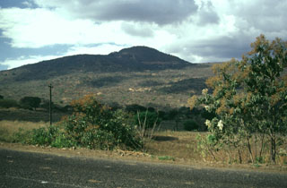 Volcán Las Viboras, north of Volcán Chingo, is a part of the Chingo volcanic field in Guatemala. Las Viboras (seen here from the north) contains a scoria cone at the summit. Recent lava flows of estimated Holocene age were erupted along this same fault on the N flank of Las Viboras and on the NW flank.
Photo by Giuseppina Kysar, 1999 (Smithsonian Institution).
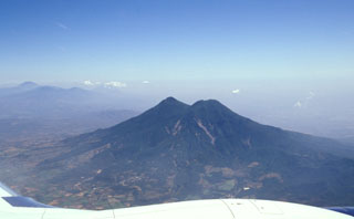 Flights from the international airport at San Salvador often pass close to San Vicente volcano, seen here from the south. The edifice is within the La Carbonera caldera, which formed during a major Plinian explosive eruption during the Pleistocene.
Photo by Paul Kimberly, 2002 (Smithsonian Institution).
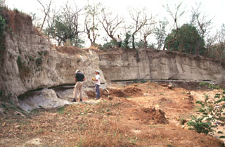 Geologists investigate an outcrop of the Tierra Blanca Joven (TBJ) formation about 10 km SE of Ilopango caldera where it originated. The TBJ was produced during the last of four major explosive eruptions that formed the caldera and deposited pyroclastic flows, ashfall, and pumice across much of central and western El Salvador. The eruption destroyed early Mayan cities and forced their abandonment for decades to centuries. Trade routes were disrupted, and the centers of Mayan civilization shifted from the highland areas of El Salvador to lowland areas to the north and in Guatemala.
Photo by Carlos Pullinger, 1996 (Servicio Nacional de Estudios Territoriales, El Salvador).
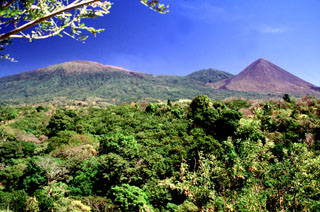 Three peaks of the Santa Ana massif can be seen from the highway between Sonsonate and San Salvador. The summit of Santa Ana volcano is to the left, the unvegetated Izalco volcano is to the right, and between them is Cerro Verde.
 Photo by Lee Siebert, 2002 (Smithsonian Institution).
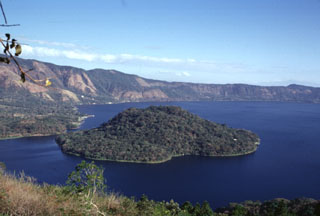 Cerro Grande is the largest of a series of post-caldera lava domes extruded along a NE-SW-trending line within Coatepeque caldera. The lava dome, seen here from the southern caldera rim, rises about 90 m above the lake surface and about 180 m above the lake floor.
Photo by Paul Kimberly, 1999 (Smithsonian Institution).
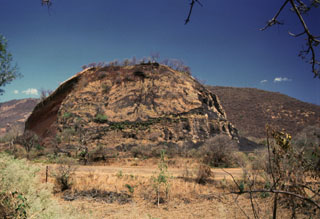 Cerro Quemado scoria cone near of the outlet of Lake Güija has been extensively quarried, and only a remnant remains. The San Diego volcanic field is along the El Salvador/Guatemala border and contains numerous scoria cones and associated lava flows on both sides of Lake Güija.
Photo by Giuseppina Kysar, 1999 (Smithsonian Institution).
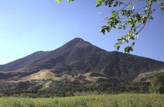 San Vicente is one of the largest volcanoes in El Salvador and is seen here from the east. The 130 km3 edifice was constructed within the Pleistocene La Carbonera caldera.
Photo by Carlos Pullinger, 1994 (Servicio Nacional de Estudios Territoriales, El Salvador).
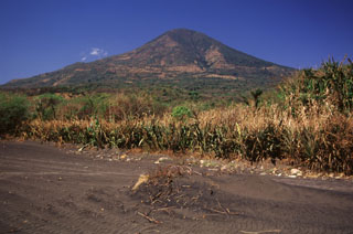 Conchagua volcano has a conical profile when seen from the NE near Punta el Chiriquín. The volcano actually has a much more complex structure than seen here and has been extensively eroded. It has two principal summits. The eastern summit, Cerro de La Bandera, seen in this view, appears morphologically more youthful and is less dissected than Cerro del Ocote, which forms the 1225 m high point of the volcanic complex.
 Photo by Rick Wunderman, 1999 (Smithsonian Institution).
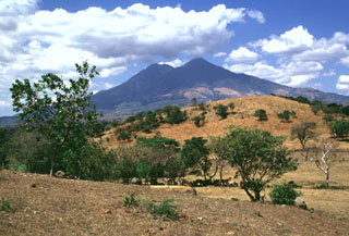 San Vicente is one of El Salvador's largest volcanoes. The hill in the foreground is a hummock of the Tecoluca debris avalanche deposit on the SE flank, with the main edifice in the background. The avalanche and associated lahars traveled about 25 km to the Río Lempa.
Photo by Lee Siebert, 1999 (Smithsonian Institution).
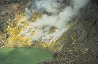 Thermal activity at the surface of a volcano is evidence of volcanic heat below. The fumarolic activity seen here produces vigorous gas-and-steam plumes along the sulfur-coated wall of the summit crater at El Salvador's Santa Ana volcano. Thermal activity is common during non-eruptive periods at many volcanoes, and may persist for many thousands of years. The interaction of high-temperature volcanic fluids and gases with groundwater in hydrothermal fields can produce geysers, hot springs, and mud pools.
Photo by Kristal Dorion, 1994 (U.S. Geological Survey).
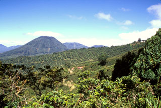 The escarpment cutting diagonally downward across the middle of the photo in front of conical Cerro los Naranjos volcano is the NW wall of a large late-Pleistocene caldera formed by edifice collapse of Santa Ana volcano. The exposed portion of the collapse scarp is up to about 200 m high along a roughly 5 km segment of the arcuate avalanche caldera. Pyroclastic ejecta and lava flows from modern Santa Ana volcano have filled in much of the scarp in the foreground and have buried it completely on the northern and eastern sides.
 Photo by Paul Kimberly, 2002 (Smithsonian Institution).
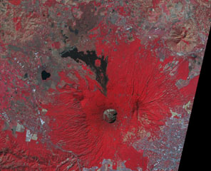 This false-color NASA ASTER image (N is at the top) looks down on the 1.5-km-wide San Salvador summit crater. The lava flow to the north was erupted from a flank vent in 1917; the small cone in the center of the summit crater also formed that year. Lake-filled Laguna de Chanmico maar lies on the lower NW flank (left-center). The capital city of San Salvador is at the lower right.
NASA ASTER image, 2001 (https://earthobservatory.nasa.gov/).
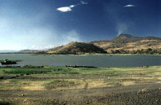 An extensive volcanic field of scoria cones and lava flows near Lake Güija is named after its largest feature, Volcán de San Diego (upper right). A large lava flow from the San Diego scoria cone dammed the drainage and was responsible for the formation of 12-km-long Lake Güija, which lies mostly in El Salvador and extends across the border into Guatemala. Cerro el Tule scoria cone in the center of the photo is near the eastern shore of the lake.
Photo by Giuseppina Kysar, 1999 (Smithsonian Institution).
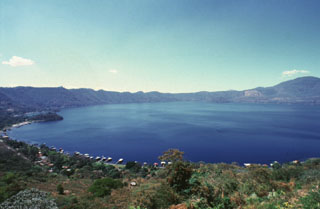 Lago de Coatepeque fills the 7 x 10 km Coatepeque caldera in western El Salvador. The caldera formed during two major eruptions in the late Pleistocene. Post-caldera eruptions produced a series of lava domes such as the one seen to the left that forms a small peninsula extending into the lake. A chain of scoria cones that erupted along caldera ring faults are across the southern caldera rim in the background.
Photo by Giuseppina Kysar, 1999 (Smithsonian Institution).
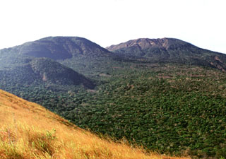 This view looking to the NW from Cerro Chino scoria cone shows some of the vents on the flank of Santa Ana, whose broad summit is to the right. The small vegetated cone in the midground to the left is Cerro el Astillero, and the larger cone behind it is Cerro Verde.
Photo by Lee Siebert, 2002 (Smithsonian Institution).
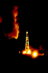 A night-time view shows a drill site at the Berlín geothermal area on the NW flank of Tecapa volcano. The Berlín Boca Pozo 1 site has an installed capacity of 10 MW and came on line in 1991. The El Tronador site began commercial operation in 1992 and generated 8 MW of power.
Photo courtesy of Comisión Ejecutiva Hidroeléctricia del Río Lempa (CEL).
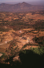 The Berlín geothermal area in the foreground is viewed from the SE on the flank of the Tecapa massif. The Pan-American highway traverses the base of the Tertiary volcanoes of Cerro Sihuatepeque (center) and Cerro Palacios (left) across the Río Lempa in the background.
Photo by Carlos Pullinger, 1996 (Servicio Nacional de Estudios Territoriales, El Salvador).
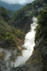 Fumaroles and sulfur deposits on the northern flank of San Vicente (or Chichontepeque) are shown in this 2011 photo. Two geothermal areas are on the N flank, located along two radial faults. These are the surface manifestations of a 12 km2 geothermal reservoir, producing thermal springs and fumaroles.
Photo by Lis Gallant, 2011.
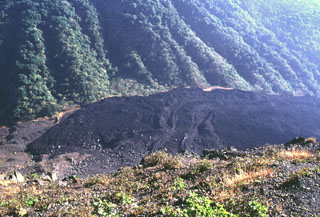 The lava flows with levees in the center of the photo were extruded from a vent on the NE flank of Izalco beginning in 1955. This lava extrusion took place during an almost continuous period of Strombolian activity from November 1948 until the end of 1957. Periods of lava effusion took place July 1950, September-November 1952, October 1954, intermittently in 1955, November 1956, and January 1957. The eruption tapered off in late 1957 and was over by the end of the year.
Photo by Lee Siebert, 1999 (Smithsonian Institution).
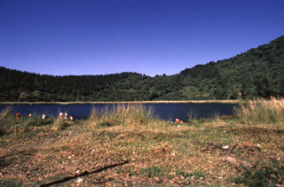 Laguna Verde is a 500-m-wide lake that partially fills the 1-km-wide summit crater of Cerro Laguna Verde in the Apaneca Range. Laguna Verde is a Pleistocene-age edifice within the Concepción de Ataco caldera. Flank craters on Laguna Verde volcano are among the youngest volcanic centers of the Apaneca Range.
Photo by Giuseppina Kysar, 1999 (Smithsonian Institution).
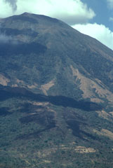 The dark-colored areas at the bottom of the photo are lava flows erupted from a SSE-flank vent of San Miguel in December 1855. The larger dark area above it extending diagonally across the image is a cloud shadow. The 1855 lava flows were erupted from a SSE-trending radial fissure and were the smallest flows erupted at San Miguel in historical time, extending only about a kilometer from the vent.
Photo by Paul Kimberly, 1999 (Smithsonian Institution).
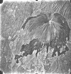 A vertical aerial photo shows the unvegetated slopes and dark-colored lava flows of Volcán de Izalco, El Salvador's youngest volcano. It originated in 1770 CE on the southern flank of Santa Ana volcano, whose summit lies to the north (top). Steep-sided, 650-m-high Izalco stratovolcano is truncated by a 250-m-wide crater. The flanks of Izalco consist primarily of pyroclastic material erupted from the summit crater; lava flows mostly originated from vents on the lower flanks and were deflected southward by the slopes of Santa Ana volcano.
Aerial photo by Instituto Geográfico Nacional El Salvador, 1996.
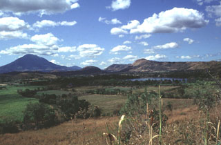 The Apastepeque volcanic field consists of a cluster of about two dozen lava domes, scoria cones, and craters NE of San Vicente volcano, the large edifice to the left. The Laguna de Apastepeque crater is to the right, below Cerro Las Delicias lava dome. Near the center of the horizon is Cerro Santa Rita lava dome.
Photo by Carlos Pullinger, 1996 (Servicio Nacional de Estudios Territoriales, El Salvador).
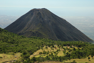 Izalco is seen here looking S from the summit of Santa Ana in 2011. The forested flank of Cerro Verde, a cone of Santa Ana, is visible on the left.
Photo by Lis Gallant, 2011.
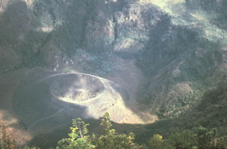 This scoria cone on the floor of the Boquerón summit crater at San Salvador was built during an eruption that began on 6 June 1917 on the upper north flank of Boquerón. A chain of scoria cones formed, and a lava flow traveled to the northwest, cutting the railroad between Quezaltepeque and Sitio del Niño. The Boquerón summit crater lake began to boil by 10 June and disappeared by 28 June, after which this small cone (Boqueroncito) formed on the crater floor.
Photo by Mike Carr, 1979 (Rutgers University).
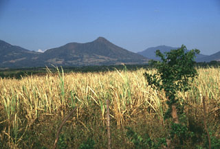 Taburete volcano (seen here from the SW) rises above the Pacific coastal plain, east of the Río Lempa. Taburete lies across an 800-m-high saddle from Tecapa volcano, visible to the left. The flat area to the left of the summit is a 150-300 m deep crater.
Photo by Lee Siebert, 1999 (Smithsonian Institution).
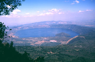 Coatepeque caldera is seen here from the summit of Cerro Verde to the SSW, a flank cone of Santa Ana volcano. Lago de Coatepeque fills the NE part of the 7 x 10 km caldera. The younger SW side of the caldera extends into Santa Ana volcano and to the sudden break in slope seen in the lower right of the photo. The caldera floor is higher on this side as a result of the accumulation of volcaniclastic debris from Santa Ana and the eruption of a series of post-caldera lava domes, one of which forms the island in the lake.
Photo by Carlos Pullinger, 1996 (Servicio Nacional de Estudios Territoriales, El Salvador).
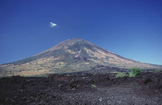 Symmetrical San Miguel volcano towers 2000 m above a barren basaltic lava flow erupted from a SE-flank vent in 1819. The conical volcano is not the highest volcano in El Salvador, but is one of the most prominent, since it rises from near sea level on the Pacific coastal plain. San Miguel (also known as Chaparrastique) is one of the most active volcanoes of El Salvador, with more than two dozen eruptions recorded since the beginning of the Spanish era.
Photo by Carlos Pullinger, 1996 (Servicio Nacional de Estudios Territoriales, El Salvador).
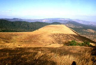 San Marcelino scoria cone is seen from Cerro Chino on the SE flank of Santa Ana. San Marcelino formed during an eruption in 1722 and produced a lava flow that traveled 13 km to the east. The vegetated southern rim of Coatepeque caldera can be seen to the NE (left) of San Marcelino.
Photo by Lee Siebert, 2002 (Smithsonian Institution).
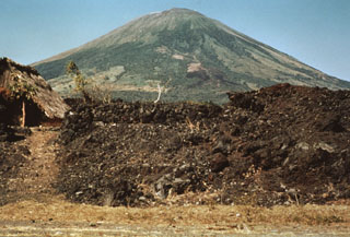 This barren lava flow issued from a fissure vent on the SE flank of San Miguel in 1819. The flow traveled about 5 km and covered a broad area below the SE base of the volcano, extending down to 25 m above sea level. Emplacement of the lava flow necessitated the construction of a new road at the base of the volcano.
Photo by Dick Stoiber, 1971 (courtesy of Bill Rose, Michigan Technological University).
 The eroded Pleistocene El Tigre volcano is seen here from the flank of Tecapa to the NW with the town of Santiago de María near the center. Two Holocene cones are seen here, Cerro Oromontique right of Santiago de María and Cerro la Manita, the small peak on the horizon to the right.
 Photo by Kristal Dorion, 1994 (U.S. Geological Survey).
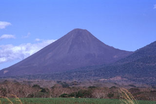 Volcán Izalco is one of El Salvador's most well-known volcanoes. It rises more than 1 km above its southern base (left) and 300 m above the saddle between it and Cerro Verde, a flank cone on Santa Ana (right). Since Izalco began erupting in 1770, the summit grew about 650 m above its original vent on the flank of Santa Ana volcano.
Photo by Paul Kimberly, 1999 (Smithsonian Institution).
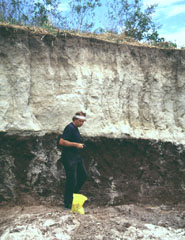 Volcanologist Jim Vallance samples the TB3 (Tierra Blanca 3) deposit, the second oldest of four major deposits associated with the formation of Ilopango caldera. This outcrop is located south of the town of Panchimalco, about 20-30 km SW of the caldera.
Photo by Carlos Pullinger, 1996 (Servicio Nacional de Estudios Territoriales, El Salvador).
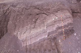 These scoria layers from Santa Ana were transported intact with only slight disruption out to about 30 km from the volcano in the Acajutla debris avalanche. A more than 20-m-thick sequence of inter-bedded tephra layers and thin lava flows within an avalanche hummock is exposed in this quarry in near Highway 2. The red-and-yellow bars on the scale mark 10-cm increments.
Photo by Paul Kimberly, 1999 (Smithsonian Institution).
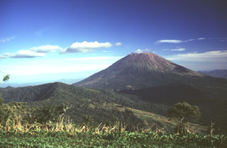 Conical San Miguel volcano, one of El Salvador's most prominent landmarks, rises across a low saddle SE of Chinameca (Pacayal) volcano. The 2130-m-high San Miguel is seen here from Cerro el Limbo, a cone on the western flank of Chinameca. The southern side of Chinameca's 2-km-wide summit caldera is visible at the left.
Photo by Carlos Pullinger, 1996 (Servicio Nacional de Estudios Territoriales, El Salvador).
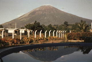 The northern slopes of the symmetrical cone of San Miguel are seen here from the city of San Miguel north of the volcano. A deep crater that has been frequently modified by historical eruptions (recorded since the early 16th century) caps the truncated summit of the basaltic-to-andesitic volcano. Radial fissures on its flanks have fed a series of fresh lava flows, including a NE-flank flow in 1762 that currently underlies the outskirts of the city of San Miguel, the third largest in El Salvador.
Photo by Bill Rose, 1971 (Michigan Technological University).
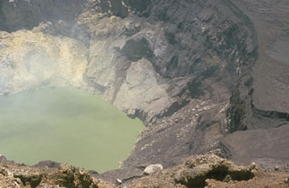 The inner crater of Santa Ana is 500 m wide and is partially filled by a 250-m-wide greenish crater lake in this 1966 photo. Fumaroles are active on the crater wall and in the lake, and abundant sulfur deposits are located on the SW wall (upper left). The acidic crater lake has a pH of about 1, and bathymetric surveys have revealed a maximum depth of 27 m.
Photo by Dick Stoiber, 1966 (Dartmouth College).
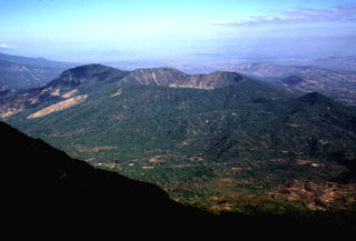 Chinameca stratovolcano is seen here from the SE near the summit of neighboring San Miguel volcano. A 2-km-wide, steep-sided caldera, Laguna Seca el Pacayal (right-center), truncates the summit of Chinameca volcano. The Holocene cone of Cerro el Limbo (in the partial shade left of the caldera) on the western flank rises to a point above the level of the caldera rim. A group of fumarole fields is located on the north flank of the volcano near the town of Chinameca, and the volcano has been the site of a geothermal exploration program.
 Photo by Lee Siebert, 1999 (Smithsonian Institution).
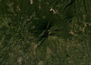 Usulután is the eroded volcano in the center of this November 2019 Planet Labs satellite image monthly mosaic (N is at the top; this image is approximately 12 km across). The eroded flank in the NE corner is El Tigre and the small cone between them is La Manita.
Satellite image courtesy of Planet Labs Inc., 2019 (https://www.planet.com/).
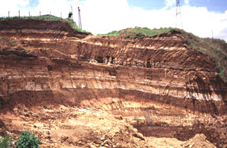 Light-colored rhyolite airfall pumice deposits from Coatepeque caldera are exposed in this quarry 20 km east of the caldera. These deposits were emplaced over much of SW El Salvador, and with the associated pyroclastic flow deposits have a volume of about 56 km3. The earlier biotite-bearing Arce deposits were produced during the largest eruption from Coatepeque about 72,000 years ago and are about 50 cmr thick at the Guatemalan border. The overlying Congo deposits originated during the second largest eruption of Coatepeque.
Photo by Carlos Pullinger, 1996 (Servicio Nacional de Estudios Territoriales, El Salvador).
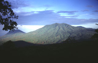 Cerro el Tigre is the NE-most and oldest of the cluster of Quaternary volcanoes between the Río Lempa and San Miguel volcano. It seen here from Chinameca volcano to its east, with Usulután volcano in the shadow to the left.
Photo by Carlos Pullinger, 1996 (Servicio Nacional de Estudios Territoriales, El Salvador).
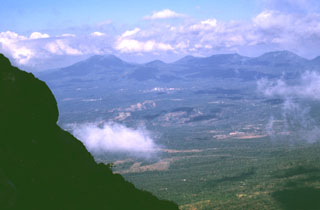 The summit of Izalco provides a view of the adjacent Apaneca Range volcanic complex to the west. The flat-topped edifice to the far-left is Cerro de Apaneca. The city of Juayua can be seen in the center of the photo. Above it is the small El Cerrito peak, and to its right is Cerro la Cumbre and the Cerro las Ninfas-Laguna Verde complex.
Photo by Lee Siebert, 1999 (Smithsonian Institution).
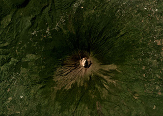 The summit crater of San Miguel, or Chaparrastique, volcano is in the center of this November 2019 Planet Labs satellite image monthly mosaic (N is at the top; this image is approximately 12 km across). Spatter and scoria cones have formed across the flanks during eruptions that emplaced lava flows up to 8 km from the vent. A flank cone that erupted a lava flow during the 1699 eruption is in the SW corner of this image (now vegetated) and the Chinameca caldera is in the NW corner.
Satellite image courtesy of Planet Labs Inc., 2019 (https://www.planet.com/).
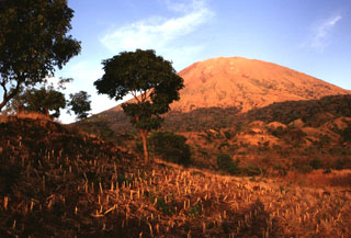 The low ridge in the left foreground is the vegetation-covered surface of a SW-flank lava flow erupted in 1867. Lava effusion began on the SW flank on December 14. Explosive activity continued, producing ashfall over the city of Usulután (20 km to the SW) and damaging tobacco plantations. The volcano was reported to be in activity again on February 2 and was particularly active on February 16. Lava fountains produced extensive scoria deposits that mantled the flow, causing it to be more vegetated than older flows.
Photo by Lee Siebert, 1999 (Smithsonian Institution).
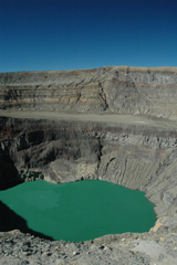 The acidic crater lake of Santa Ana is within the deepest of the nested summit craters, seen here from the S in 2011. The floor of a larger crater is visible across the center of this photo, and both lava flows and deposits from explosive eruptions are exposed in the crater walls.
 Photo by Lis Gallant, 2011.
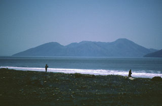 Isla Meanguera, located in the Gulf of Fonseca SE of Conchagüita Island, consists of an elongated line of three small stratovolcanoes of Pleistocene age. A N-S-trending graben cuts the summits of all three volcanoes. A circular crater occupies the summit of the central cone, which forms the island's high point at 493 m.
Photo by Rick Wunderman, 1999 (Smithsonian Institution).
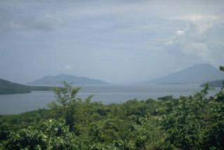 Conchagüita (left), an island in the Gulf of Fonseca, and Conchagua (right) a volcano on the Salvadoran mainland are seen here across the Gulf of Fonseca from the NE on the island of Zacate Grande in Honduras. Both Conchagüita and Conchagua are extensively eroded, but a historical eruption was reported from Conchagüita. The NW flank of Isla El Tigre volcano forms the ridge extending into the sea at the extreme left.
Photo by Mike Carr, 1991 (Rutgers University).
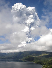 An ash-and-steam plume from Santa Ana towers above Coatepeque caldera lake. The one-hour explosive eruption the morning of 1 October 2005 produced plumes that rose 10 km or more. Ash fell in towns west of the volcano and extended into Guatemala. Volcanic blocks up to a meter in diameter fell as far as 2 km south of the summit. Lahars descended valleys on the flanks of the volcano.
Photo by José Roberto Lopez, 2005 (Coatepeque Watershed Authority).
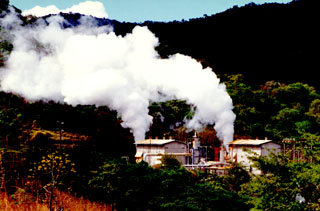 Steam clouds pour from the Berlín 2 well. The Berlín geothermal field on the NW flank of the Tecapa volcanic complex is one of the largest in El Salvador. The Berlín 2 site has an installed capacity of 55 MW with a potential of 55-150 MW. Measured well temperatures ranged from 240-300 degrees Centigrade.
Photo courtesy of Comisión Ejecutiva Hidroeléctricia del Río Lempa (CEL).
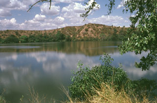 A solitary, 600-m-wide lake, Laguna Aramuaca, occupies a low-lying area about 10 km SE of the city of San Miguel. The low northern wall of the maar is seen here from the southern rim of the 1-km-wide crater. The Pan-American highway swings around the south side of the maar, which was erupted through sediments immediately north of the Río Grande de San Miguel. The rim of the maar rises about 50-100 m above the countryside and reaches only 181 m above sea level.
 Photo by Lee Siebert, 1999 (Smithsonian Institution).
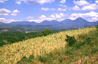 The Apaneca Range is seen here from the SE. This elongated group of Pleistocene and Holocene edifices lies in western El Salvador, between the Santa Ana complex and the Guatemala border. The 5-km-wide Pleistocene Concepción de Ataco caldera lies beyond the flat ridge to the left; to its right are Cerro Cachio, Cerro de las Rana, Cerro el Aguila, and conical Cerro los Naranjos. The Apaneca Range is the site of the major geothermal field of Ahuachapán.
Photo by Lee Siebert, 1999 (Smithsonian Institution).
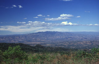 The broad massif of Cerro Cacahuatique lies in the interior valley of El Salvador about 30 km NNE of San Miguel volcano. The massive 1500-m-high Pleistocene stratovolcano (also spelled Cerro Cacaguatique) rises 1000 m above its base and is deeply dissected, although it still retains its subdued conical form. A large erosional caldera, formed through a breach on the SE side, truncates the summit.
 Photo by Carlos Pullinger, 1999 (Servicio Nacional de Estudios Territoriales, El Salvador).
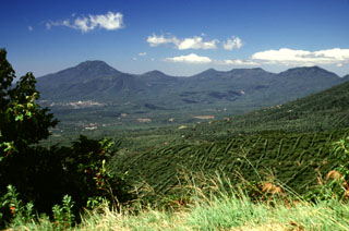 Cerro de Apaneca is to the left above the city of Juayua. To its right is Cerro la Cumbre and the Cerro las Ninfas-Laguna Verde complex. Construction of the latter post-dated major Pleistocene explosive eruptions that resulted in formation of the Pleistocene Concepción de Ataco caldera.
Photo by Lee Siebert, 2002 (Smithsonian Institution).
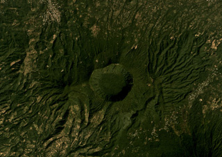 The 2.4-km-wide Laguna Seca el Pacayal is the caldera of Chinameca in the center of this December 2019 Planet Labs satellite image monthly mosaic (N is at the top). The smaller cone on the SW flank is Cerro el Limbo with a summit reaching above the caldera rim.
Satellite image courtesy of Planet Labs Inc., 2019 (https://www.planet.com/).
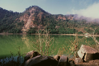 The Loma San Juan peak lies along the northern crater rim of Laguna de Alegría, a crater lake at the summit of Tecapa. Geothermal features are active along the rim of the crater lake and an area of hydrothermally altered clay containing up to 45% sulfur is found nearby.
Photo by Giuseppina Kysar, 1999 (Smithsonian Institution).
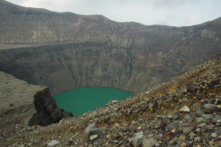 The Santa Ana crater lake is in the smallest and deepest of several nested craters across the summit that formed during successive explosive events, seen here in 2011 from the western side on the terrace level. The acid sulfate-chloride lake has a pH around 1, with an associated subsurface hydrothermal system that releases gases into the water.
Photo by Lis Gallant, 2011.
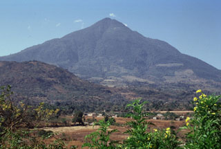 The easternmost peak of San Vicente is seen here from the NE along the road to the city of San Vicente. The hill in the foreground (left) is Cerro Ramírez, a flank cone that is one of the most recent features of the volcanic complex.
 Photo by Paul Kimberly, 1999 (Smithsonian Institution).
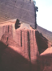 Oxidized red scoria deposits are exposed in a quarry on Cerro el Cerrito, a scoria cone on the lower northern flank of San Salvador immediately SE of the town of Quezaltepeque.
Photo by Carlos Pullinger, 1996 (Servicio Nacional de Estudios Territoriales, El Salvador).
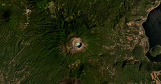 Santa Ana (or Ilamatepec) has several nested summit craters, with the active crater containing the blue lake shown in this February 2021 Planet Labs satellite image monthly mosaic (N is at the top; this image is approximately 16 km across). Several small cones have formed along the SE flank, down to the San Marcelino scoria cone that emplaced the 13-km-long lava flow eastwards in 1722. The Coatepeque Caldera is to the E and the Apaneca Range is to the W.
Satellite image courtesy of Planet Labs Inc., 2021 (https://www.planet.com/).
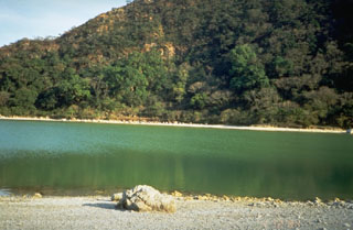 The Tecapa volcano summit contains the 600-m-wide Laguna de Alegría crater lake, seen here from the west. The 0.9 x 1.3 km crater is elongated in an E-W direction and lies about 300 m below the summit.
 Photo by Kristal Dorion, 1994 (U.S. Geological Survey).
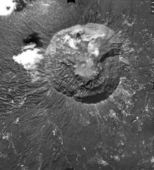 The summit of San Salvador volcano is truncated by a large steep-walled crater, Boquerón (the mouth), which formed during a major eruption producing the San Andrés Talpetate Tuff about 800 years ago. Eruption of west-directed airfall tephra was accompanied by pyroclastic flows. The small 30-m-high cinder cone, Boqueroncito (the little mouth) is seen in the center of the crater floor of 1.5-km-wide, 500-m-deep Boquerón and was constructed during the 1917 eruption.
Aerial photo by Instituto Geográfico Nacional El Salvador, 1979.
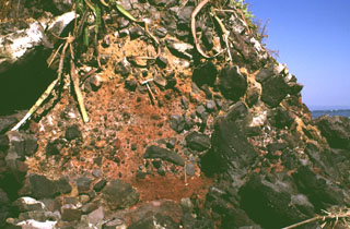 Large clasts in an oxidized scoria matrix of the Acajutla debris avalanche deposit are exposed at the Pacific Ocean coastline more than 40 km from Santa Ana volcano. Clasts with a jigsaw fracture pattern can be seen at the top of the photo and clasts at least 6 m in diameter are nearby. Note the rock hammer in the center for scale.
Photo by Lee Siebert, 1999 (Smithsonian Institution).
 San Vicente rises about 2 km above the Pacific coastal plain of El Salvador. The volcano has formed within the Pleistocene La Carbonera caldera and has buried the eastern caldera rim. The edifice and caldera are within the 20-30 km wide Central Graben within Tertiary volcanic basement rocks.
Photo by Lee Siebert, 1999 (Smithsonian Institution).
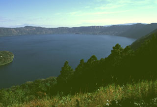 Lago de Coatepeque is within the eastern part of Coatepeque caldera, seen here from the southern caldera rim. The NE part of the caldera formed following the eruption of 40 km3 of rhyolitic pumice-fall and pyroclastic flow deposits about 72,000 years ago. The northern caldera rim in the distance rises about 250 m above the lake, which had a maximum depth of about 120 m when this photo was taken in 1999. Hot springs are located at several points along the shore of the lake near a group of post-caldera lava domes.
Photo by Lee Siebert, 1999 (Smithsonian Institution).
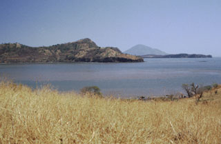 Isla Zacatillo lies in the Gulf of Fonseca only 2 km from Punta el Chiquirín, the eastern tip of El Salvador. The low, roughly 3-km-wide island is crudely rectangular in shape, but has a peninsula extending to the NE. A steep escarpment truncates the western side of the island, seen here. NNW-SSE-trending faults cut lava flows on the island. The conical peak in the distance is Isla el Tigre in Honduras.
Photo by Rick Wunderman, 1999 (Smithsonian Institution).
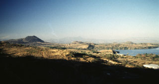 A panoramic view from the NE shows from left to right Volcán de San Diego, Cerro Masatepeque, and Loma Iguana. Laguna de Metapán is to the right. San Diego is the largest cone of a volcanic field surrounding Lake Güija on the El Salvador/Guatemala border. Lava flows from smaller vents of the San Diego volcanic field were responsible for blocking drainages and forming Laguna de Metapán, and the larger Lago de Güija was formed as a result of flows from Volcán de San Diego.
Photo by Giuseppina Kysar, 1999 (Smithsonian Institution).
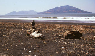 Conchagüita (right) and Meanguera (left) volcanoes lie across a narrow strait from Punta El Chiquirín in eastern El Salvador. Conchagüita is the youngest of the two small volcanic islands in the Gulf of Fonseca and had an historical eruption in 1892. The more eroded Isla Meanguera volcano ceased activity during the Pleistocene.
Photo by Giuseppina Kysar, 1999 (Smithsonian Institution).
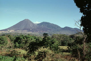 Izalco has been one of El Salvador's most active volcanoes during historical time. More than 50 eruptions took place since it began to erupt in 1770, many lasting several years to about a decade in duration. Eruptions took place both from the summit craters and from flank vents. Unvegetated lava flows are seen here on the SE flank below Cerro Verde (center) and El Conejal and El Astillero (right).
Photo by Paul Kimberly, 1999 (Smithsonian Institution).
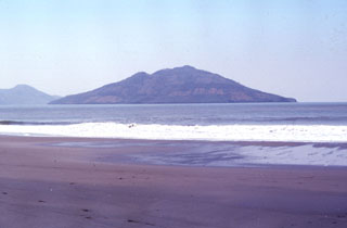 Conchagüita volcano occupies a small, 4-km-wide island in the Gulf of Fonseca across a narrow strait from Conchagua volcano. Conchagüita is seen here from Punta El Chiquirín, the easternmost point on the Salvadoran mainland. Late-stage eruptions formed a small, sharp-topped cone with a 100-m-wide summit crater at the southern end of the low 550-m-high island. Minor ash emissions in 1892 marked the only reported historical eruption from Conchagüita. Meanguera Island can be seen beyond Conchagüita at the left.
Photo by Francesco Frugioni, 1999 (Istituto Nazionale di Geofisca e Vulcanologia, Rome).
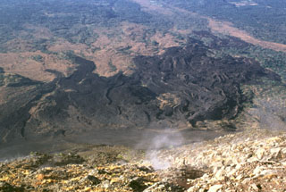 A lava flow field on the SW flank of Izalco is seen here from its summit. Levees define distinct flows of the lava field, which extends up to about 7 km from the summit. Most of the flows seen here were emplaced prior to 1954. Gas rises from fumaroles near the summit.
Photo by Lee Siebert, 1999 (Smithsonian Institution).
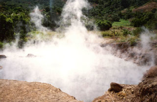 Steam rises above a hot pool at Agua Shuca, one of many thermal areas of the Ahuachapán geothermal field. A sudden hydrothermal explosion at Agua Shuca in October 1990 ejected steam and debris within a 200-m-radius, and 26 people living adjacent to the thermal area were killed. The Agua Shuca thermal area ESE of Laguna Verde volcano had historically been one of the most frequently visited areas at Ahuachapán. A previous explosion apparently took place in 1868.
Photo by Pat Dobson, 1999 (Lawrence Berkeley National Laboratory).
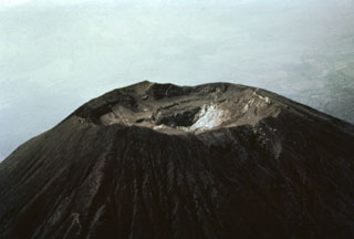 The summit of San Miguel volcano was reported to be peaked prior to the 16th century, but now is truncated by a 1-km-wide crater. This aerial view shows the 2130 m high point on the far NE crater rim in the center of the photo and several benches cut by a roughly 250-m-deep central crater. The morphology of the crater has varied greatly during historical time as a result of the creation and subsequent destruction of new craters. A cinder cone that formed in the NE part of the crater in 1884 had disappeared 50 years later.
 Photo by Willard Parsons, 1964 (courtesy of Bill Rose, Michigan Technological University).
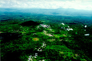 This aerial view shows the Ahuachapán-3 geothermal power plant. The Ahuachapán-Chipilapa geothermal field has an installed capacity of 95 MW and a potential of 95-150 MW. It covers an area of 200 km2 in the counties of Santa Ana, Ahuachapán, and Sonsonate. The field was the first developed in El Salvador, and the first plants came on line in 1975. During the 1980s the field was over-exploited and generated more than 40% of the country's electricity. After the reservoir pressure dropped rapidly, generation was stabilized at 48 MW.
Photo courtesy of Comisión Ejecutiva Hidroeléctricia del Río Lempa (CEL).
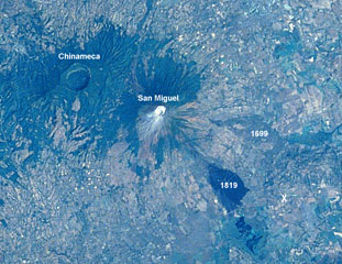 A large eruption took place from San Miguel in 1699, accompanied by strong earthquakes, flames, and rumblings. A major lava flow (right-center) traveled from SE-flank fissures for a straight-line distance of nearly 9 km. The flow divided around a light-colored kipuka and then banked against Pleistocene volcanic hills, where it was deflected to the south in a narrow lobe to the point labeled "X." The 2.5-km-wide caldera of Chinameca volcano lies across a saddle from San Miguel in this Space Shuttle image with north to the upper left.
 NASA Space Shuttle image STS61C-31-47, 1986 (http://eol.jsc.nasa.gov/).
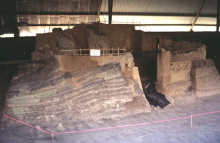 An excavation at the Joya de Cerén archaeological site in the Zapotitán Valley shows pyroclastic surge deposits from the 590 CE eruption of the Laguna Caldera scoria cone against Mayan buildings. The excavation has unearthed several small Protoclassic Mayan homesteads that were buried by this eruption on the northern flank of San Salvador. They contain the remains of uneaten meals left by occupants who evacuated their houses.
Photo by Giuseppina Kysar, 1999 (Smithsonian Institution).
 Santa Ana has four nested craters at its summit, seen here from the SW. A series of flank vents and cones have formed along a 20-km-long fissure system that extends from the lower NNE flank to the San Marcelino and Cerro Chino scoria cones on the SE flank. Historical eruptions have been recorded since the 16th century and have largely consisted of small-to-moderate explosions from both summit and flank vents.
Photo by Mike Carr, 1982 (Rutgers University).
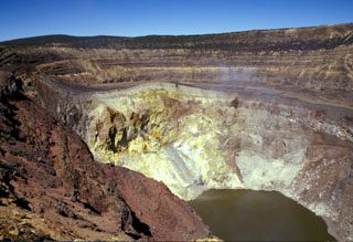 Gases rise from the hydrothermally altered western wall of Santa Ana's inner summit crater above the acidic lake. A steep path down the NE crater wall (far right) provides access to the lake for geochemical sampling. Sequences of phreatomagmatic tephra units more than 100 m thick are exposed in the walls of the outer summit craters.
Photo by Paul Kimberly, 2002 (Smithsonian Institution).
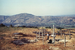 San Vicente is one of several volcanoes that have been the sites of geothermal exploration projects in El Salvador. The SV-1 well in the foreground is located on the northern flank. The low Cerro el Cerrón lava dome, part of the Apastepeque volcanic field, is to the NE on the left horizon.
Photo courtesy of Comisión Ejecutiva Hidroeléctricia del Río Lempa (CEL), 1992.
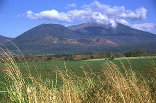 The rounded vegetated peak in the background and to the left is Cerro Verde on the SSE flank of Santa Ana, to the right. The broad edifice in front of them is the Cerro la Olla-Cerro Marcelino scoria cone complex on the Santa Ana flank. Cerro Marcelino at the right side of the cone complex formed during the 1722 eruption, when the Teixcal lava flow traveled 13 km E and destroyed San Juan Tecpan village.
Photo by Lee Siebert, 1999 (Smithsonian Institution).
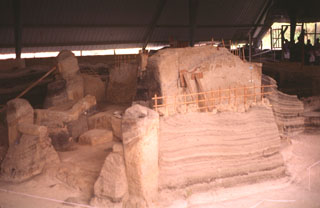 Laminated pyroclastic surge deposits surround the walls of houses buried by an eruption from the Laguna Caldera scoria cone on the lower NW flank of San Salvador. This eruption occurred around 590 CE and buried at least three Mayan homesteads beneath more than 4 m of scoria and ash.
Photo by Giuseppina Kysar, 1999 (Smithsonian Institution).
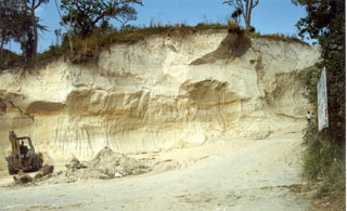 Pyroclastic flow and ashfall deposits from Ilopango caldera, known collectively as Tierra Blanca (White Soil), are found over much of central and western El Salvador. This quarry near the city of Cojutepeque (9 km ENE of the caldera) exposes the Tierra Blanca Joven (TBJ) formation that was produced during the youngest of several Tierra Blanca eruptions about 1,500 years ago. The eruption destroyed early Mayan cities and resulted in their abandonment for decades to centuries.
Photo by Giuseppina Kysar, 1999 (Smithsonian Institution).
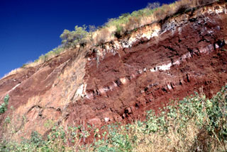 A quarry exposes red, oxidized scoria deposits with interbedded lighter lava flow units (possibly due to surface alteration) at Cerro la Leona scoria cone on the northern rim of Coatepeque caldera. The stratigraphy of the adjacent Cerro la Leona and Cerro Cañitas cones on the NE caldera rim were exposed by the caldera ring faults. At least ten other scoria cones on the eastern and southern caldera rims overlap ring faults.
 Photo by Lee Siebert, 2002 (Smithsonian Institution).
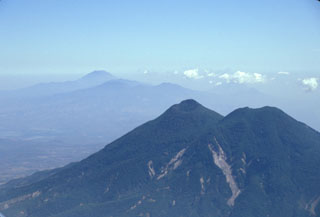 San Vicente is seen here in 2002 with landslide scarps that were produced during the January 2001 earthquake. The San Vicente area and towns at the base of the volcano were particularly affected by the tectonic earthquake and suffered extensive damage. The Tecapa volcanic complex and conical San Miguel volcano are in the distance.
Photo by Paul Kimberly, 2002 (Smithsonian Institution).
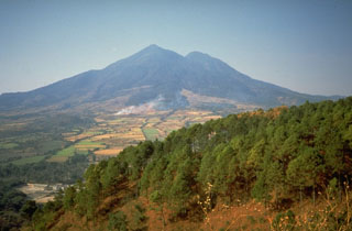 San Vicente is seen here from the north along the Pan-American highway. Numerous hot springs and fumaroles are found on its flanks.
Photo by Kristal Dorion, 1994 (U.S. Geological Survey).
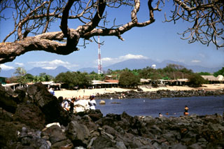 The massive Acajutla debris avalanche swept into the sea, forming a peninsula that extended the shoreline about 7 km. The rocks in the foreground and across the bay at Playa Los Cobanos are the farthest subaerial extent of the avalanche, 41 km from its source at Santa Ana volcano on the horizon to the right. Hummocks are exposed to the coastline and are visible well offshore on bathymetric surveys, which suggest that the avalanche deposit has a significant submarine component.
Photo by Lee Siebert, 2002 (Smithsonian Institution).
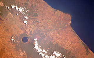 The Acajutla Peninsula is the largest topographic irregularity along a 900-km-long stretch of the Pacific coast between the Gulf of Tehuantepec off Oaxaca, México and the Gulf of Fonseca at the SE tip of El Salvador. The 20-km-wide peninsula was created by a debris avalanche that traveled nearly 50 km following the late-Pleistocene collapse of Santa Ana volcano, located beneath the cloud bank to the right of Coatepeque lake. Part of the shallow submarine component of the deposit is visible in this International Space Station image with north to the lower left.
NASA International Space Station image ISS004-701-34, 2002 (http://eol.jsc.nasa.gov/).
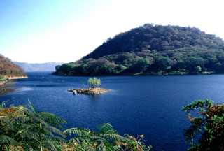 This vegetated island is Cerro Grande, a post-caldera lava dome in the SW side of Coatepeque caldera. The partially submerged dome has a basal diameter of about 2.5 km and a volume of about 0.5 km3. The smaller San Pedro Island with one tree is exposed during low lake levels.
Photo by Lee Siebert, 2002 (Smithsonian Institution).
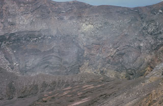 The active Santa Ana crater lies at the SE end of series of four nested summit craters and contains a small lake not visible in this photo. The northern crater wall in the background exposes a series of lava flows and inter-bedded pyroclastic deposits. Several faults are visible in the crater walls, such as the one at the upper left. Later tectonic movements produced a graben in the central part of the crater with displacements of 50-70 m.
 Photo by Bill Rose, 1966 (Michigan Technological University).
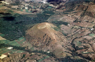 Cerro La Olla is one of a chain of young scoria cones erupted on either side of Volcán Chingo. The southern vents, including Cerro La Olla, lie in El Salvador, while the northern vents, the largest of which is Volcán Las Viboras, are in Guatemala.
Photo by Paul Kimberly, 1999 (Smithsonian Institution).
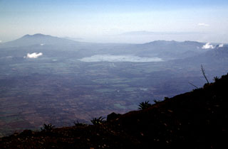 The twin peaks of Volcán Conchagua appear in the distance on the left horizon in this view to the east from the summit of San Miguel volcano. Conchagua lies on the shore of the Gulf of Fonseca at the SE tip of El Salvador. The large lake in the center of the photo is Laguna de Olomega. Flat-topped Cosiqüina volcano in Nicaragua is visible in the far distance at the upper right across the Gulf of Fonseca.
Photo by Lee Siebert, 1999 (Smithsonian Institution).
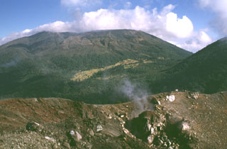 Santa Ana rises beyond the Izalco summit crater, which began erupting in 1770 on the northern Santa Ana flank. Fumarolic activity continues at Izalco, producing the faint steam plume in the right foreground, but has diminished considerably since the 200-year-long eruptive period ended in 1966. A complex of four nested craters gives the summit of Santa Ana a flat profile. The flank of Cerro Verde is seen to the right.
Photo by Lee Siebert, 1999 (Smithsonian Institution).
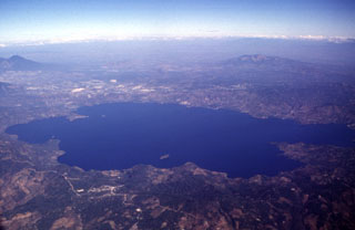 The 13 x 17 km Ilopango caldera is filled by one of El Salvador's largest lakes. The caldera, which has a scalloped 150-500 m high rim, lies immediately east of the capital city of San Salvador (upper left). The latest caldera collapse event occurred during the massive 536-550 CE eruption, which produced widespread pyroclastic flows and devastated early Mayan cities. Post-caldera eruptions formed a series of lava domes within the lake and near its shore.
Photo by Carlos Pullinger, 1996 (Servicio Nacional de Estudios Territoriales, El Salvador).
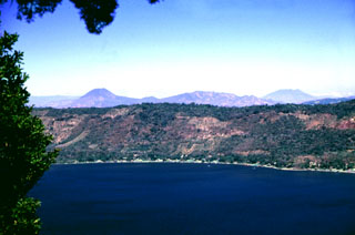 The northern wall of Coatepeque caldera rises about 250 m above the surface of Lago de Coatepeque, whose shores are lined with residences and small hotels. The peak beyond the caldera to the left is Volcán Chingo along the El Salvador/Guatemala border. The broader peak to the far right is Volcán Suchitán, one of the largest volcanoes in SE Guatemala.
 Photo by Lee Siebert, 2002 (Smithsonian Institution).
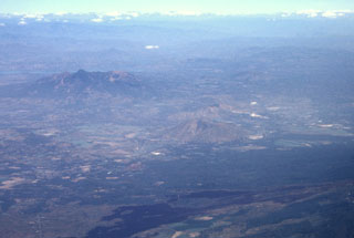 The massive Pleistocene Guazapa stratovolcano (left-center) is seen here in an aerial view from the SW with the Río Lempa behind it. The youngest flank vent of Guazapa is Cerro Macanze, which lies on the SE flank of the volcano, behind the two small volcanoes in the right-center part of the photo. The dark-colored unvegetated lava flow in the foreground was erupted in 1917 from the flank of San Salvador volcano.
Photo by Paul Kimberly, 1999 (Smithsonian Institution).
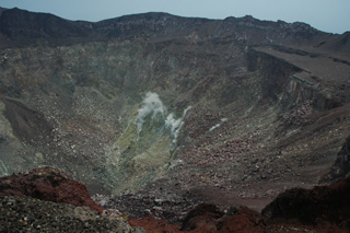 The roughly 800-m-wide San Miguel crater is seen here in 2011 with fumaroles in the geothermal area on the far crater wall producing small gas-and-steam plumes. Different colors in the crater walls are from various levels of oxidation and geothermal alteration of the rock.
Photo by Lis Gallant, 2011.
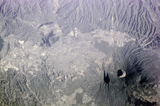 The capital city of San Salvador extends across much of this photo taken from the International Space Station (with north to the bottom) and encroaches on the flanks of San Salvador volcano. The Boquerón crater is 1.5 km wide and lies within a late-Pleistocene crater whose eastern wall is shown by the shadow to the left. The dark area to the bottom right is a flank lava flow produced during the 1917 eruption.
NASA International Space Station image ISS001-E-5903, 2001 (http://eol.jsc.nasa.gov/).
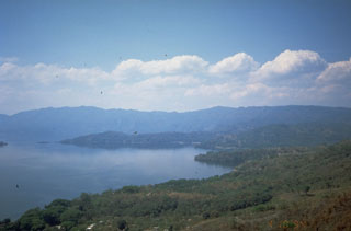 The SW wall of Ilopango caldera rises about 500 m above the surface of the caldera lake. Punta La Peninsula (center) on the western side of the caldera extends a kilometer into the lake. The high wall on the southern side of the lake is a fault scarp in southward-dipping rocks of the Pliocene Balsamo formation. The scenic lake is a popular resort destination from the capital city of San Salvador, and the shores of the lake are dotted with resorts and vacation homes.
 Photo by Kristal Dorion, 1994 (U.S. Geological Survey).
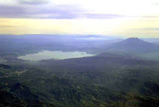 Ilopango caldera is seen in this aerial view from the SW with San Vicente stratovolcano to the right. The latest collapse of the 13 x 17 km caldera occurred after a powerful eruption during 536-550 CE that produced widespread pyroclastic flows and devastated early Mayan cities. The caldera now contains a lake with lava domes forming small islands near the shore and near its center.
Copyrighted photo by Stephen O'Meara.
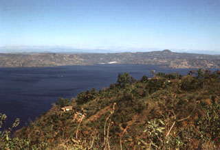 The two tiny islands in the center of Lake Ilopango barely visible above the house in the foreground are the Islas Quemadas. These are post-caldera lava domes that were emplaced from 31 December 1879 to March 1880. A huge ash plume with incandescent ejecta were erupted on 20 January and the dome breached the lake surface on 23 January. It reached a height of 50 m above the lake surface before violent explosions on 5 March destroyed most of the visible part of the dome.
Photo by Bill Rose, 1978 (Michigan Technological University).
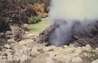 Ausoles de la Labor fumaroles and hot pools form one of the largest geothermal areas in the Ahuachapán geothermal field. The area is located near the SW base of the Cerro San Lazaro lava dome, about 5 km N of Laguna Verde volcano. The Ahuachapán geothermal field contains fumaroles, mud volcanoes, or hot springs, throughout a roughly 80 km2 area on the northern flank of the Apaneca Range.
Photo by Giuseppina Kysar, 1999 (Smithsonian Institution).
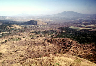 The Teixcal lava flow is the brownish area extending diagonally from the lower left towards San Salvador volcano on the right horizon. It originated during an eruption in 1722 from the base of San Marcelino scoria cone, where this photo was taken. The lava is noted for its disequilibrium textures, where large orthopyroxene crystals are surrounded by olivine reaction rims. The half-forested, half-vegetated cone near the center is Cerro Alto, a scoria cone of Coatepeque caldera (out of view to the left).
Photo by Lee Siebert, 2002 (Smithsonian Institution).
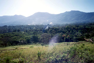 The Laguna Las Ninfas-Laguna Verde volcanic complex is seen here from the NW with steam plumes of the Ahuachapán geothermal field in the midground. The 5-km-wide Concepción de Ataco caldera formed during the late Pleistocene following the eruption of about 70 km3 of pyroclastic flows and airfall tephra. Flat-topped Laguna Verde at the center of the photo and Las Ninfas at the right are post-caldera cones. Cerro Cuyanausul (left) was constructed prior to caldera formation and lies to the east of the caldera.
Photo by Pat Dobson, 1999 (Lawrence Berkeley National Laboratory).
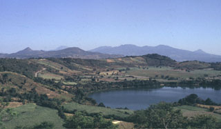 Laguna de Apastepeque in the foreground is one of several lake-filled maar craters in the Apastepeque volcanic field. The broad range in the distance to the right is the SE is the Tecapa massif. To the far right is the peak of Volcán Taburete. San Miguel volcano is in the midground to the left.
Photo by Carlos Pullinger, 1994 (Servicio Nacional de Estudios Territoriales, El Salvador).
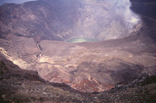 Santa Ana's active crater contains an acidic crater lake within the SE end of a series of four nested craters. This photo is taken from the northern rim of the second youngest crater and shows an older crater floor containing several small phreatomagmatic vents that formed during historical eruptions.
Photo by Carlos Pullinger, 1996 (Servicio Nacional de Estudios Territoriales, El Salvador).
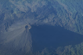 This aerial view shows Izalco with south at the top of the photo. The cone was constructed during frequent eruptions over a two-century period beginning in 1770. Strombolian eruptions from the summit crater were sometimes accompanied by lava flows that traveled down the flank to the south, extending as far as 7 km from the summit.
Copyrighted photo by Stephen O'Meara.
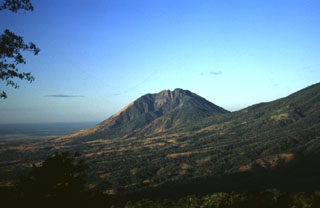 A large 1.3 km wide valley on the eastern flank of Usulután volcano is seen here from the flanks of Chinameca to its NE, with the Pacific Ocean in the distance to the left.
 Photo by Carlos Pullinger, 1996 (Servicio Nacional de Estudios Territoriales, El Salvador).
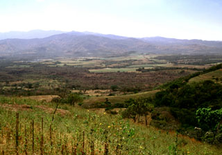 The brownish area extending across the center of the photo is the 1722 Teixcal lava flow. Erupting from the base of San Marcelino scoria cone on the SE flank of Santa Ana (out of view to the right), the flow traveled 13 km E to the edge of the Zapotitán basin and destroyed the village of San Juan Tecpán as well as burying about 15 km2 of agricultural land.
 Photo by Lee Siebert, 2002 (Smithsonian Institution).
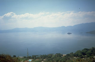 The 8 x 11 km Ilopango caldera, filled by one of El Salvador's largest lakes, has a scalloped 150-500 m high rim. The caldera, seen here from its west rim, is strongly controlled by regional faults of the central Salvador graben. Its latest collapse resulted from the massive 5th century CE Tierra Blanca eruption that produced widespread pyroclastic flows and devastated early Mayan cities. The latest of a series of post-caldera eruptions formed the Islas Quemadas, a group of low islets in the center of the lake, in 1879-1880.
Photo by Kristal Dorion, 1994 (U.S. Geological Survey).
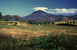 This view of Volcán Chingo from the SE side shows several smaller cones on the Salvador side of the volcano. Loma Los Siete Cerros is to the left, and the rounded cone of Cerro Laguneta to the right.
Photo by Giuseppina Kysar, 1999 (Smithsonian Institution).
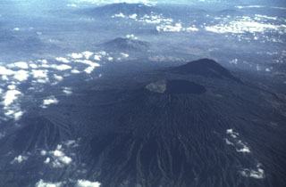 Boquerón volcano, its summit cut by a steep-walled, 500-m-deep crater, was constructed within a 6-km-wide caldera whose largely obscured rims are visible in this aerial photo from the WSW. The caldera cut an older San Salvador edifice, remnants of which are visible at El Picacho peak (in the shadow behind Boquerón) and El Jabalí (the low peak at the lower left). The buried caldera rim in the foreground is defined by the change in degree of dissection of the volcano's flanks. Guazapa volcano can be seen in the distance at the top of the photo.
Photo by Carlos Pullinger, 1996 (Servicio Nacional de Estudios Territoriales, El Salvador).
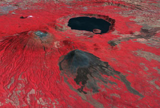 This false-color oblique DEM overlain by a thermal infrared ASTER image shows Santa Ana volcano (middle left), Izalco volcano (center), and the roughly 5.5 x 6 km Coatepeque caldera lake from the SW. The summit of Santa Ana has series of nested craters, and a NW-SE-trending fissure across the edifice. Lava flows were recently emplaced across the southern flanks of Izalco. The grayish area at the far upper left is the city of Santa Ana, El Salvador.
NASA ASTER image, 2001 (https://earthobservatory.nasa.gov/).
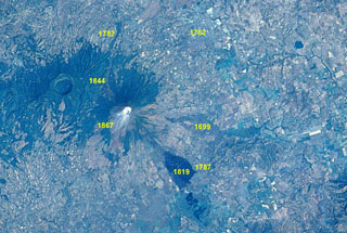 An eruption at San Miguel on September 21-23, 1787 from summit and N- and SE-flank vents produced five lava flows. Ashfall caused extensive crop damage. Other historical lava flows from San Miguel are labeled in this Space Shuttle image with north to the upper left. The 1762 lava flow (faintly seen at the upper right) extended as far as the present-day city of San Miguel. The 2.5-km-wide caldera of Chinameca volcano lies NW of San Miguel volcano, and the small dark-colored dot at the upper right is Laguna de Aramuaca maar.
 NASA Space Shuttle image STS61C-31-47, 1986 (http://eol.jsc.nasa.gov/).
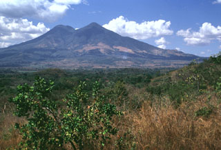 San Vicente is seen here from the SE. The modern edifice is largely constructed of thick lobate lava flows that originated primarily from summit vents and a vent on the eastern flank.
Photo by Lee Siebert, 1999 (Smithsonian Institution).
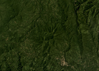 The eroded Pleistocene Cerro Buena Vista is in the center of this October 2019 Planet Labs satellite image monthly mosaic (N is at the top; this image is approximately 13 km across). It is located in the Jucuarán Range in the SE corner of El Salvador, and on the southern flank In Cerro Madrecacao, also heavily eroded and Pleistocene in age.
Satellite image courtesy of Planet Labs Inc., 2019 (https://www.planet.com/).
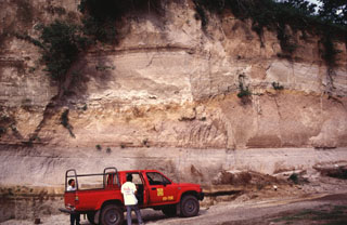 Rhyolite pumice fall and pyroclastic flow deposits from the two caldera-forming eruptions (Arce and Congo) at Coatepeque are exposed in this quarry wall. The lower Arce pumice and overlying pyroclastic flow deposit have a total volume about 40 km3 and were emplaced during the 72,000 BP eruption that formed the NE part of the caldera. The upper deposits (above the undulating brown paleosol in the center of the photo) are from the 16 km3 Congo eruption prior to about 57,000 years ago and were erupted through a caldera lake.
Photo by Carlos Pullinger, 1996 (Servicio Nacional de Estudios Territoriales, El Salvador).
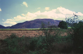 The summit of Cerro las Tablas contains a chain of three N-S-trending craters and is located west of Cerro Singüil in the interior valley of El Salvador. Cerro las Tablas is the highest feature of the Cerro Singüil volcanic field and is seen here from the west.
Photo by Giuseppina Kysar, 1999 (Smithsonian Institution).
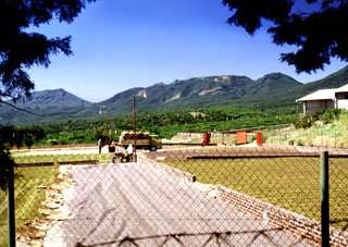 Coffee beans dry in the sun at a finca near the town of San José la Majada in the SE part of the Apaneca range. Coffee is the primary crop in this portion of El Salvador; fertile volcanic soil and abundant rainfall provide excellent habitat for coffee trees across the flanks of the volcanoes of the Apaneca range and Santa Ana massif. The Cerro las Ninfas-Laguna Verde complex forms the ridge on the horizon.
Photo by Lee Siebert, 2002 (Smithsonian Institution).
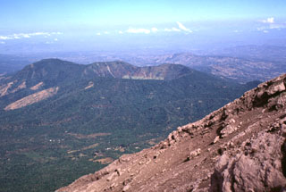 Chinameca volcano, also known as El Pacayal, is seen here to the NW from the barren upper flanks of San Miguel volcano. Coffee plantations mantle the slopes of the 1300-m-high stratovolcano, which is truncated by a 2-km-wide caldera. The high point of the caldera, Cerro el Pacayal, lies on the western rim (left-center) and rises about 450 m above the caldera floor. The rounded peak of Cerro el Limbo at the left rises to above 1380 m, exceeding the height of the caldera rim.
 Photo by Lee Siebert, 1999 (Smithsonian Institution).
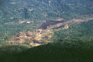 The sparsely vegetated basaltic lava flow cutting diagonally across the photo to the upper right was erupted from a NNW-flank vent in 1844. The flow traveled initially to the NNW toward the broad saddle between San Miguel and Chinameca volcanoes and then was deflected to the NE. It traveled in a narrow lobe as far as 8 km from the summit near the path of the present-day road between the town of San Jorge and the city of San Miguel.
Photo by Lee Siebert, 1999 (Smithsonian Institution).
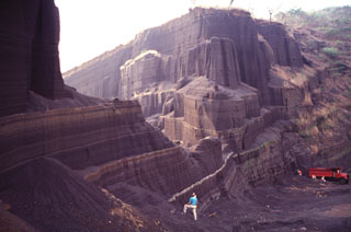 Bedded scoria deposits that formed the flanks of a basaltic scoria cone are exposed in a quarry at Cerro Singüil. This cone is the largest of a small cluster of cones in El Salvador's interior valley, SE of Volcán Chingo. These cones are part of a broad area of monogenetic basaltic volcanism near the Guatemalan border.
Photo by Carlos Pullinger, 1996 (Servicio Nacional de Estudios Territoriales, El Salvador).
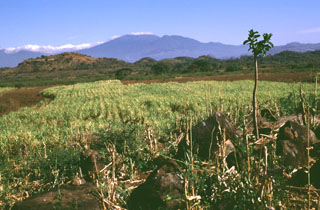 Santa Ana volcano, seen in the distance more than 30 km to the north, underwent catastrophic edifice collapse during the late Pleistocene. This produced a massive, highly mobile, debris avalanche that emplaced the boulders in the foreground and formed the small hummocks across the center. The larger hill to the left is composed of the older Bálsamo formation, which was surrounded by the avalanche. This avalanche was one of the largest known in Central America and traveled nearly 50 km from the volcano.
Photo by Lee Siebert, 1999 (Smithsonian Institution).
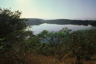 The low SW rim of Aramuaca maar is reflected in the waters of 600-m-wide Laguna de Aramuaca. The maar was erupted through sediments in a plain north of the Río Grande de San Miguel.
 Photo by Giuseppina Kysar, 1999 (Smithsonian Institution).
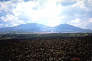 The barren lava flow in the foreground was formed during a 1917 eruption from vents on the flank of Boquerón stratovolcano, the rounded peak at the left. The lava flow cut the railway SW of Quezaltepeque. The 1917 eruption also produced a small cinder cone in the summit crater of Boquerón. Boquerón has grown within a 6-km-wide caldera whose western rim forms El Jabalí peak (right). Three fracture zones that extend beyond the base of the volcano have been the locus for numerous flank eruptions of Santa Ana volcano.
 Photo by Kristal Dorion, 1994 (U.S. Geological Survey).
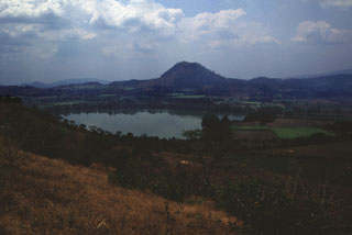 Cerro El Cerrón, one of the largest lava domes of the Apastepeque volcanic field, is seen here beyond Laguna de Apastepeque.
 Photo by Giuseppina Kysar, 1999 (Smithsonian Institution).
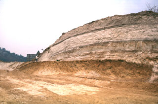 Four major pyroclastic units associated with the incremental formation of Ilopango caldera are exposed in this quarry. The Tierra Blanca (White Soil) unit that was emplaced over much of central and western El Salvador consists of (from bottom to top) the Pleistocene TB4 (the orange-colored unit at the base), TB3, and TB2 units (separated by thin soils), and the Holocene TBJ unit. The latter is called the Tierra Blanca Joven (the young Tierra Blanca) and was erupted about 1,500 years ago. Note the geologist on the left side of the outcrop for scale.
 Photo by Carlos Pullinger, 1996 (Servicio Nacional de Estudios Territoriales, El Salvador).
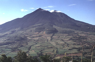 Lobate lava flows are seen on the northern flank of San Vicente. These and other flows of San Vicente were emplaced within 7 km of the summit and are overlain by pumice of the Tierra Blanca Joven (TBJ) formation, erupted from neighboring Ilopango caldera about 1,500 years ago.
 Photo by Carlos Pullinger, 1994 (Servicio Nacional de Estudios Territoriales, El Salvador).
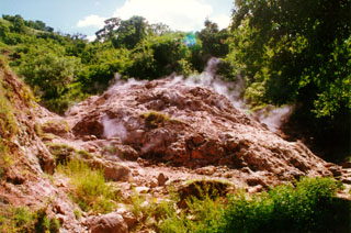 Gases rise from fumaroles within hydrothermally altered rock on the Chinameca northern flank. Fumarole fields surround the city of Chinameca on several sides, within a few kilometers of the town.
Photo courtesy of Comisión Ejecutiva Hidroeléctricia del Río Lempa (CEL).
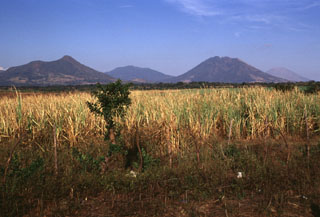 Four volcanoes of the 40-km-long Sierra Tecapa range rise to the NE above the Pacific coastal plain. From left to right are Volcán Taburete, El Tigre, Usulután, and San Miguel,
Photo by Lee Siebert, 1999 (Smithsonian Institution).
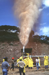 A plume rises from well CH-D during its opening in 1996. The Ahuachapán geothermal field was the first major field to be developed in El Salvador and has been operating since 1975. The geothermal field is located mostly in permeable, highly fractured Pliocene-Pleistocene volcanic rocks of the San Salvador formation that are capped by a series of young pyroclastic rocks and lava flows. A younger system of NW-trending faults localizes hydrothermal features within a series of step faults dropping to the north at the margin of the Central Salvadoran Graben.
Photo by Carlos Pullinger, 1996 (Servicio Nacional de Estudios Territoriales, El Salvador).
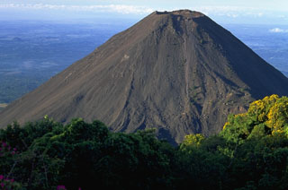 Volcán de Izalco is seen here from the north, on the southern flank of Santa Ana. It began erupting in 1770 CE and frequent Strombolian eruptions produced a steep-sided, 650-m-high stratovolcano over a 200-year period. Izalco was one of the most frequently active volcanoes in Central America, producing ejecta and lava flows from both summit and flank vents.
Copyrighted photo by Stephen O'Meara.
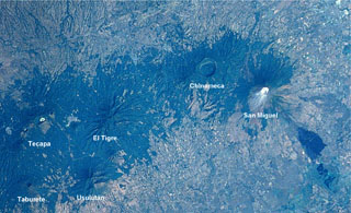 An E-W-trending chain of volcanoes extends about30 km across eastern El Salvador. The 2-km-wide Laguna Seca el Pacayal caldera is a prominent feature of Chinameca volcano. San Miguel is one of El Salvador's most active volcanoes; the dark area at the lower right is a lava flow from the 1819 eruption. The city of San Miguel is to the upper right.
NASA Space Shuttle image STS61C-31-47, 1986 (http://eol.jsc.nasa.gov/).
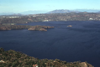 The western side of Lake Ilopango is seen from the southern rim of Ilopango caldera. The broad peak on the right-hand horizon is the Pleistocene Guazapa volcano. The northern wall of Ilopango caldera rises about 400-500 m above the lake. Much of the caldera rim contains thick caldera-forming eruption deposits, and some lava domes are exposed in the caldera wall.
Photo by Bill Rose, 1978 (Michigan Technological University).
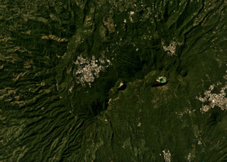 The Tecapa volcanic complex contains the cones and craters through the center of this November 2019 Planet Labs satellite image monthly mosaic (N is at the top; this image is approximately 12 km across). The craters in the NE-SW line from the one in the center in this image are Hoyon (center), Cerro Peylon, and Cerro Las Palmas; the Ausoles de la Laguna de Alegría thermal area is within the crater containing the lake towards the E.
Satellite image courtesy of Planet Labs Inc., 2019 (https://www.planet.com/).
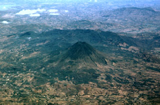 Volcán Chingo is located along the Guatemala/El Salvador border. This aerial view is from the SW, the Guatemala side. The border with El Salvador extends from the bottom-right part of the photo through Volcán Chingo to Lake Guija at the upper left corner of the photo.
Photo by Paul Kimberly, 1999 (Smithsonian Institution).
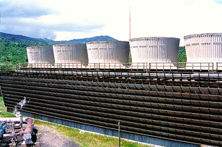 The cooling towers of the Ahuachapán-3 power plant are part of a geothermal field that has been producing for more than a quarter century. The liquid-dominated geothermal reservoir has a base temperature of about 240 degrees centigrade. It is located on the northern flank of the Apaneca (Cuyanausul) Range along the southern margin of the Salvadoran central graben. Consequently it is lower to the north and NW, where it has been affected by graben subsidence.
Photo courtesy of Comisión Ejecutiva Hidroeléctricia del Río Lempa (CEL).
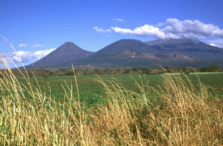 The broad Santa Ana volcano is to the right, with Izalco volcano to the left in this NW-looking view from the Zapotitán basin. The cone in the center is Cerro Verde, and the smaller, low-profile scoria cone below it is Cerro Marcelino. Historical eruptions have occurred from the summit crater of Santa Ana and flank cones such as Cerro Marcelino to the SE. Izalco formed in 1770, and the saddle between Izalco and Cerro Verde increased 100 m in height in the century after 1866.
Photo by Lee Siebert, 1999 (Smithsonian Institution).
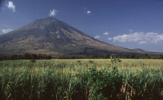 San Miguel is one of the most prominent volcanoes in El Salvador. Its southern slopes, seen here, rise more than 2000 m above the farmlands on the Pacific coastal plain. Both summit and flank vents have been active during historical time. The dark-colored lava flow at the right-center was erupted from a SE-flank vent in 1819.
Photo by Rick Wunderman, 1999 (Smithsonian Institution).
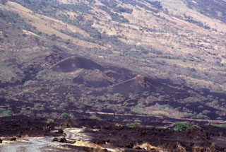 Small cinder cones on the lower SE flank of San Miguel between about 300 and 400 m altitude were constructed along a radial fissure that also was the source of a voluminous basaltic lava flow (foreground) erupted in 1819. The flow traveled about 5 km and covered a broad area below the base of the volcano.
Photo by Paul Kimberly, 1999 (Smithsonian Institution).
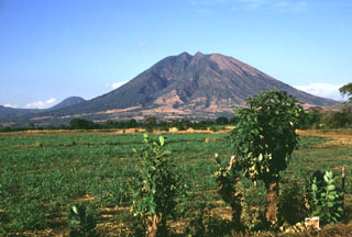 Usulután is part of a cluster of volcanoes north of the Pacific coastal plain between San Vicente and San Miguel, seen here from the SSW. Cerro Oromontique, the small peak to the left, formed on the flank of El Tigre. Relatively young lava flows are on the southern flank.
Photo by Lee Siebert, 1999 (Smithsonian Institution).
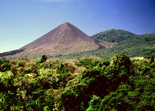 Izalco grew to its present height during a 200-year period since it began erupting in 1770 at an elevation of about 1,300 m on the flank of Santa Ana. Intermittent Strombolian eruptions and the effusion of dominantly basaltic-andesite lava flows built up the volcano so that by the year 1866 the summit was at 1,825 m elevation, by 1866 it was at 1,825 m, by 1892 it was at 1,885 m, by 1951 it was at 1,900 m, by 1953 it was at 1,935, and by 1956 it was at 1,965 m.
Photo by Lee Siebert, 2002 (Smithsonian Institution).
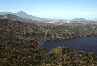 The SW corner of Ilopango caldera is visible in the foreground with the outskirts of the capital city of San Salvador behind it. The high peak on the left horizon (NW) is El Picacho, part of the San Salvador volcanic complex, a recently active volcano overlooking the capital city. Below it to the left is San Jacinto, a Pliocene lava dome complex. The broad peak in the background to the right is the Pliocene Cerro Nejapa volcano.
Photo by Bill Rose, 1978 (Michigan Technological University).
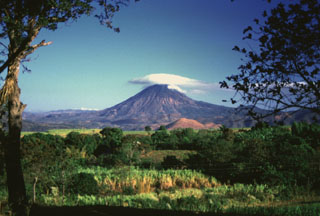 Volcán Chingo is located on the Guatemala/El Salvador border, seen here from the SE on the Salvador side of the border. The light-brown hill below is Cerro Laguneta. Other flank vents are located on the NE side and several recent lava flows are to the west and north.
Photo by Giuseppina Kysar, 1999 (Smithsonian Institution).
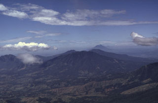 This view from the summit of San Miguel shows the E-W-trending volcanic chain between it and San Vicente volcano, the peak in the distance to the right. The flank of Chinameca in the foreground (right) and the broad El Tigre volcano is in the center. Behind El Tigre are the peaks of the Tecapa volcanic complex and to the far left is Usulután.
Photo by Carlos Pullinger, 1996 (Servicio Nacional de Estudios Territoriales, El Salvador).
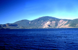 Santa Ana volcano rises above Lago de Coatepeque. The 6-km-wide lake lies at the eastern end of the Coatepeque caldera. The northern and southern rims of the western side of the caldera are visible beyond the lake. The rounded peak to the left of Santa Ana is Cerro Verde, one of many cones along a NW-SE-trending fissure cutting across the Santa Ana complex.
Photo by Lee Siebert, 2002 (Smithsonian Institution).
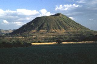 Cerro Singüil is rises 250 m above the floor of El Salvador's interior valley and is seen here from the NW, along the Pan-American highway.
Photo by Rick Wunderman, 1999 (Smithsonian Institution).
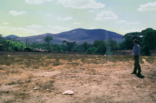 Cerro las Tunas is seen here from the NE, just south of the town of Aguilares. Las Tunas is a Pleistocene volcano that is part of the Cerro Cinotepeque volcanic field, an area of small stratovolcanoes and cones of Pleistocene-to-Holocene age on either side of the Río Lempa, west of Guazapa volcano.
Photo by Giuseppina Kysar, 1999 (Smithsonian Institution).
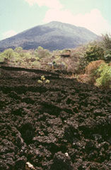 The basaltic lava flow in the foreground originated during a major effusive eruption that began from fissure vents on the NNW flank of San Miguel on July 25, 1844. By December lava was confined to the crater. The volcano then entered a several-year-long period of explosive activity. Another lava flow was reported in 1848, the year the eruption ended.
Photo by Paul Kimberly, 1999 (Smithsonian Institution).
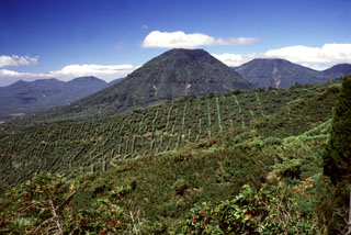 The escarpment across the middle of the photo with vertical rows of coffee plantation trees across the scarp in is the NW wall of a large caldera formed by edifice collapse of Santa Ana volcano during the late Pleistocene. About 5 km of the scarp is exposed; the remainder is buried beneath ejecta and lava flows from modern Santa Ana volcano. Cerro los Naranjos volcano rises beyond the scarp, and other peaks of the Apaneca range form the horizon on either side.
Photo by Lee Siebert, 2002 (Smithsonian Institution).
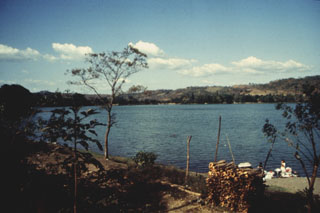 Laguna de Apastepeque is one of several large lake-filled maars in the Apastepeque volcanic field. The 800-m-wide lake is about 50 m deep and is surrounded by ash deposits containing angular blocks of andesite.
Photo courtesy of Comisión Ejecutiva Hidroeléctricia del Río Lempa (CEL), 1992.
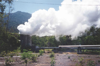 Steam plumes rise from the AH-16 production well at the Ahuachapán geothermal field. The Ahuachapán field, producing since 1975, is a high-temperature initially water-dominated system located on the flank of Laguna Verde volcano about 2 km NW of the summit.
Photo by Pat Dobson, 1999 (Lawrence Berkeley National Laboratory).
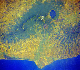 Four volcanoes in western El Salvador are visible in this Space Shuttle image. The forested ridge at the left-center is the Apaneca Range, a complex of calderas and small stratovolcanoes. The summit crater of Santa Ana volcano lies below the small cloud bank, and the brownish area below it is Izalco volcano. A circular lake partially fills Coatepeque caldera. The Acajutla Peninsula at the bottom, named after the port city of Acajutla, was formed by a massive debris avalanche produced by the late-Pleistocene collapse of Santa Ana volcano.
NASA Space Shuttle image STS61C-31-45, 1986 (http://eol.jsc.nasa.gov/).
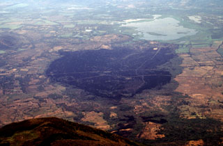 The dark sparsely vegetated area in the center of the photo marks basaltic lava flows erupted on the SE flank of San Miguel volcano in 1819. The flows, seen here from the summit of San Miguel, originated from fissure vents on the lower SE flank in July 1819 and traveled about 5 km downslope toward Laguna el Jocotal (upper right). The small lava flows at the lower right-center were erupted in December 1855. The principal coastal highway and the national railway of El Salvador cross the 1819 flows.
Photo by Lee Siebert, 1999 (Smithsonian Institution).
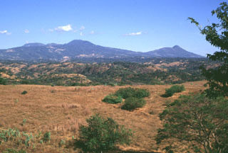 The Tecapa volcanic complex (left) and Volcán Taburete (right) rise to the east of the Río Lempa, which is hidden beyond the slope in the foreground. They are at the western end of the 40-km-long Tecapa-San Miguel volcano cluster in eastern El Salvador. Ignimbrites from a caldera-forming eruption at Tecapa were emplaced beyond the Río Lempa.
Photo by Lee Siebert, 1999 (Smithsonian Institution).
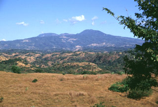 Tecapa is at the NW end of a cluster of volcanoes in eastern El Salvador between San Vicente and San Miguel, seen here from the west. The peaks on the horizon to the far left lie behind the Berlín caldera. Geothermal activity continues within the Tecapa volcanic complex and a producing geothermal plant is located at the Berlín geothermal field.
Photo by Lee Siebert, 1999 (Smithsonian Institution).
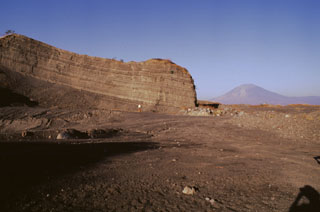 Bedded pyroclastic-surge deposits are exposed in a quarry at Laguna de Aramuaca, SE of the city of San Miguel. Conical San Miguel volcano rises 18 km to the west in the right background. Note the person in the center for scale.
Photo by Giuseppina Kysar, 1999 (Smithsonian Institution).
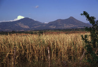 The Tecapa volcanic complex (left) and Volcan Taburete (right) are separated by a 800-m-high saddle. They are seen here from the SW rising more than 1100 m above the Pacific coastal plain and lie at the eastern end of a volcanic chain reaching to San Miguel volcano. A relatively young lava flow is found on the southern flank of Taburete volcano, although its age is not known precisely. Fumarolic activity continues at Tecapa, the site of a major geothermal project.
Photo by Lee Siebert, 1999 (Smithsonian Institution).
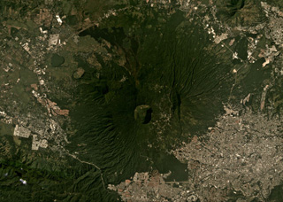 The 1.5-km-wide Boquerón crater of San Salvador is in the center of this November 2019 Planet Labs satellite image monthly mosaic (N is at the top), with the small Boqueroncito scoria cone in the center. A 6 x 4.5 km caldera formed around 40-30 ka and the current El Boquerón edifice was built within it. Recent activity was concentrated in the northern sector with lava flows emplaced on the N flank and within the crater.
Satellite image courtesy of Planet Labs Inc., 2019 (https://www.planet.com/).
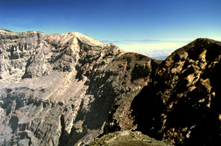 The eastern crater rim of Santa Ana rises more than 100 m above the crater floor. The eastern wall is composed of breccias, scoria units, thin lava flows, and dikes. Thick sequences of lava flows are exposed in the northern and southern crater walls and on the southern side they are overlain by phreatomagmatic tephra layers up to 100 m thick.
Photo by Lee Siebert, 2002 (Smithsonian Institution).
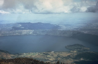 Coatepeque caldera iseast of Santa Ana volcano. The eastern caldera rim rises about 250 m above the lake surface in this 1972 photo. Post-caldera eruptions included the formation of basaltic scoria cones and flows near the western margin, and the extrusion of lava domes (such as Cerro Grande forming the island to the right) along a NE-SW line near the caldera lake margins.
 Photo by Dianne Neilson, 1972 (courtesy of Dick Stoiber, Dartmouth College).
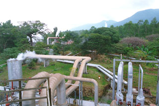 Steam lines going to the power plant snake across the surface of the Ahuachapán-Chipilapa geothermal field in western El Salvador. The field is located on the northern flank of the Sierra de Apaneca range 15 km from the Guatemala border. The Ahuachapán-Chipilapa field was the first to be developed in El Salvador and began production in 1975.
Photo courtesy of Comisión Ejecutiva Hidroeléctricia del Río Lempa (CEL).
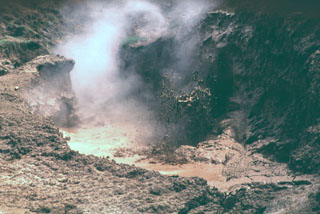 Los Infiernillos Cantón las Meses geothermal area at Chinameca volcano features a cluster of mudpools. This is part of a series of geothermal fields surrounding the city of Chinameca.
Photo by Carlos Pullinger, 1994 (Servicio Nacional de Estudios Territoriales, El Salvador).
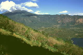 Santa Ana is seen here from the east on the rim of Coatepeque caldera. The eastern rim of Santa Ana's summit crater was breached and produced the gently sloping deposits extending towards the caldera lake to the lower right. The NW wall of the caldera in the background cuts into the flanks of Santa Ana. This SW part of Coatepeque caldera formed about 57,000 years ago during the eruption of about 16 km3 of rhyolite pumice and pyroclastic flow deposits.
Photo by Lee Siebert, 1999 (Smithsonian Institution).
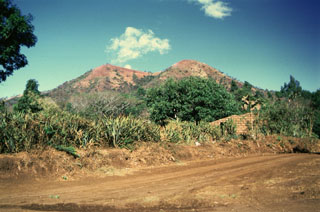 Loma Los Siete Cerros (Peak of the Seven Hills) is part of the Volcán Chingo volcanic field. This complex of overlapping scoria cones on the Salvadoran side is seen here from the east and is one of many flank vents. Among the youngest vents are those that produced lava flows on the NW side in Guatemala. Other young flows erupted from an intermittent chain of cones extending N-S on both side of the summit.
Photo by Giuseppina Kysar, 1999 (Smithsonian Institution).
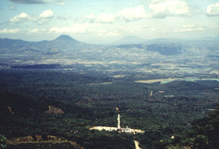 This view from the Apaneca Range shows the CH-A well and drill rig of the Ahuachapán geothermal field in the foreground. The peak on the left horizon across the lowlands of El Salvador's interior valley is Volcán Chingo, along the El Salvador/Guatemala border. The flatter peak to the far right is Volcán Suchitán in Guatemala.
Photo by Comisión Ejecutiva Hidroeléctricia del Río Lempa (CEL), 1992.
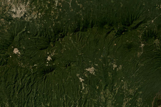 The E-W trending Apaneca Range is across the middle of this November 2019 Planet Labs satellite image monthly mosaic (N is at the top; this image is approximately 25 km across). The range includes the roughly E-W ridge along the upper half of this image, and the two cones below it – the linear Cerro de Apaneca and Cuyotepe just E of it. The crater on the western end of the ridge is Laguna las Ninfas, and the small lake NE is Cerro Laguna Verde. West of those is the Concepción de Ataco caldera.
Satellite image courtesy of Planet Labs Inc., 2019 (https://www.planet.com/).
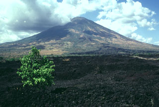 This sparsely vegetated basaltic lava flow was erupted from a fissure vent on the lower SE flank of San Miguel in 1819. The flow covers a broad 2.5-km-wide, 5-km-long area on the low-angle slopes below the volcano and reaches down to an elevation of less than 40 m above sea level. The principal coastal highway of El Salvador traverses the flow below the point of this photo, and the national railway crosses the flow closer to the vent.
Photo by Lee Siebert, 1999 (Smithsonian Institution).
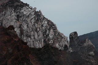 This 2011 photo taken at the summit of San Miguel shows a lava flow around 10 m thick overlying darker oxidized scoria and agglutinate deposits. Eruptions have also taken place across the flanks, producing lava flows and ashfall that caused extensive crop damage.
Photo by Lis Gallant, 2011.
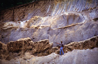 The thick light-colored unit the volcanologist is pointing to is the Arce fall deposit, overlying a paleosol and mafic ash and scoria deposits. This outcrop is about 15 km NW of the caldera rim. The biotite-rich rhyolitic Arce pumice-fall deposit was erupted from Coatepeque caldera about 72,000 years ago and was associated with formation of the SW part of the caldera. Deposits of the 84,000-year-old Los Chocoyos Ash from Atitlán caldera in Guatemala lie about 3 m below the base of the Arce deposit, but are not visible in this photo.
 Photo courtesy of Carlos Pullinger, 1996 (Servicio Nacional de Estudios Territoriales, El Salvador).
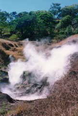 This geothermal area known as Chinameca 4 is one of several surrounding the city of Chinameca. Temperatures of around 100°C have been recorded at the fumaroles of Ausoles la Volcancito, Ausoles el Boquerón, and Infiernillos de Chinameca. The high heat flow has made this area the object of geothermal exploration.
 Photo courtesy of Comisión Ejecutiva Hidroeléctricia del Río Lempa (CEL).
This is a compilation of El Salvador volcano information sources, such as official monitoring or other government agencies.
| Volcano Observatories | |
|---|---|
| Servicio Nacional de Estudios Territoriales (SNET) | |
| - SNET Special Reports | |
| Ministerio de Medio Ambiente y Recursos Naturales (MARN) | |
| - MARN Notices | |
| Volcanic Ash Advisory Center | |
|---|---|
| Washington Volcanic Ash Advisory Center (VAAC) | |
| - Washington VAAC Archive | |
| - Washington VAAC Notices | |